
Saint-Quentin-en-Yvelines–Montigny-le-Bretonneux station
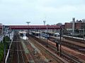
Saint-Quentin-en-Yvelines–Montigny-le-Bretonneux is a station on the Paris–Brest railway. It is served by Paris's express suburban rail system, the RER Line C and by suburban Transilien Line N and U services. The station opened in 1975.[1] It is within Montigny-le-Bretonneux.
-

-
-

-
 Bus interchange


| Preceding station | SNCF | Following station | ||
|---|---|---|---|---|
toward Template:Transilien stations | Template:Transilien lines | toward Template:Transilien stations |
||
toward Template:Transilien stations | Template:Transilien lines | toward Template:Transilien stations |
||
| Terminus | Template:RER lines | toward Template:RER stations |
See also
References
- ^ Société de géographie (1976). Acta geographica (in French). Société de géographie. p. 38.
External links
Wikimedia Commons has media related to Gare de Saint-Quentin-en-Yvelines - Montigny-le-Bretonneux.
- Saint-Quentin-en-Yvelines–Montigny-le-Bretonneux station at Transilien, the official website of SNCF (in French)
48°47′14″N 2°02′40″E / 48.78722°N 2.04444°E
This Réseau Express Régional article is a stub. You can help Wikipedia by expanding it. |