
Shalë, Albania
Shalë | |
|---|---|
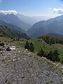
 Shalë river valley | |
.svg) Shalë | |
| Coordinates: 42°18′N 19°48′E / 42.300°N 19.800°E | |
| Country | |
| County | Shkodër |
| Municipality | Shkodër |
| Population (2011) | |
| • Municipal unit | 1,804 |
| Time zone | UTC+1 (CET) |
| • Summer (DST) | UTC+2 (CEST) |
| Website | www |
Shalë is a former municipality in the Shkodër County, northwestern Albania. At the 2015 local government reform it became a subdivision of the municipality Shkodër.[1] The population at the 2011 census was 1,804.[2] Its name comes from the Shala tribe which lives in the area. The municipal unit covers the upper course of the river Shalë, and part of the Prokletije mountains. There are eleven small mountain villages in the municipality: Breg-Lumi, Abat, Nicaj-Shalë, Lekaj, Vuksanaj, Pecaj, Theth, Ndërhysaj, Gimaj, Nen-Mavriq, Mekshaj, and Lotaj.[3]
Gallery
-
 Theth valley
 -
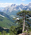 Theth valley


References
- ^ Law nr. 115/2014 Archived 2015-09-24 at the Wayback Machine
- ^ 2011 census results Archived 2016-03-03 at the Wayback Machine
- ^ Albanian Association of Communes Archived 2011-07-24 at the Wayback Machine (in Albanian)
External links
Subdivisions of Shkodër County | ||
|---|---|---|
County Seat: Shkodër | ||
| Municipality of Fushë-Arrëz |  | |
| Municipality of Malësi e Madhe | ||
| Municipality of Pukë | ||
| Municipality of Shkodër | ||
| Municipality of Vau i Dejës | ||
Subdivisions of Shkodër Municipality | ||
|---|---|---|
Municipal Seat: Shkodër | ||
| Administrative Unit of Ana e Malit |  | |
| Administrative Unit of Bërdicë | ||
| Administrative Unit of Dajç |
| |
| Administrative Unit of Guri i Zi | ||
| Administrative Unit of Postribë |
| |
| Administrative Unit of Pult |
| |
| Administrative Unit of Rrethinat |
| |
| Administrative Unit of Shalë | ||
| Administrative Unit of Shkodër | ||
| Administrative Unit of Shosh |
| |
| Administrative Unit of Velipojë |
| |
This article about a specific location in Shkodër County, Albania, is a stub. You can help Wikipedia by expanding it. |