Goryeong County
Appearance
This article relies largely or entirely on a single source. (August 2018) |
Goryeong
고령군 | |
|---|---|
| Korean transcription(s) | |
| • Hangul | 고령군 |
| • Hanja | 高靈郡 |
| • Revised Romanization | Goryeong-gun |
| • McCune-Reischauer | Koryŏng-gun |
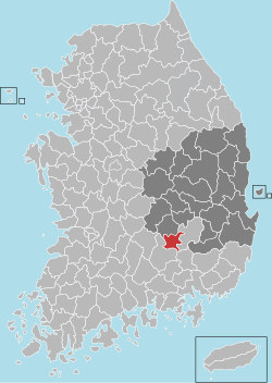
 Location in South Korea | |
| Country | |
| Region | Yeongnam |
| Administrative divisions | 1 eup, 7 myeon |
| Area | |
| • Total | 383.7 km2 (148.1 sq mi) |
| Population (2004) | |
| • Total | 35,000 |
| • Density | 91.2/km2 (236/sq mi) |
| • Dialect | Gyeongsang |
Goryeong County (Goryeong-gun) is a county in North Gyeongsang Province, South Korea.
Goryeong is a historical center of the ancient kingdom of Daegaya.
Twin towns – sister cities
Goryeong is twinned with:
See also
External links
35°43′49″N 128°16′08″E / 35.7302777878°N 128.268888899°E


