
Fore Street, Ipswich

Fore Street, Ipswich has been a prominent street in Ipswich, Suffolk since the fifteenth century.[1]
History
_Fore_Street,_Ipswich.png)
In the fifteenth century Fore street was at the centre of the wool trade handling the exports from the wool towns of Hadleigh, Kersey and Lavenham. There were a number of extensive complexes of buildings between the street and the quay. However that of Isaac Lord is the only surviving complete example of such architecture.[1]
Historic images
-
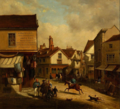 Angel Corner, Fore Street c. 1850 by Thomas Smythe
 -


Notable People
- Thomas Eldred (1561–1624), mariner, lived at 97 Fore Street
- Edith Maud Cook, aviator born in 90 Fore Street, 1878.
- Cor Visser ran the Fore Street Gallery at 44 Fore Street from 1962-1982.[2]
References
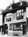
- ^ a b Norman, John (2017). "Ipswich Icons: The history of the former Neptune Inn in Fore Street, Ipswich". No. 23 July 2017. Ipswich Star.
- ^ "Visser, Cor". suffolkartists.co.uk. Suffolk Artists. Retrieved 21 July 2019.
Wikimedia Commons has media related to Category:Fore Street, Ipswich.