Vamdrup
Vamdrup | |
|---|---|
town | |
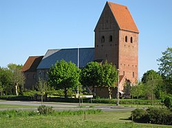
 Vamdrup church | |
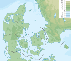
| Coordinates: 55°25′48″N 9°17′15″E / 55.42999°N 9.28740°E | |
| Country | Denmark |
| Region | Southern Denmark (Syddanmark) |
| Municipality | Kolding |
| Area | |
| • Urban | 4.44 km2 (1.71 sq mi) |
| Population (2020) | |
| • Urban | 4,869 |
| • Urban density | 1,100/km2 (2,800/sq mi) |
| Time zone | UTC+1 (CET) |
| • Summer (DST) | UTC+2 (CEST) |
| Postal code | DK-6580 Vamdrup |
Vamdrup is a town in the Region of Southern Denmark, near Kolding in Denmark with a population of 4,869 (1 January 2020).[1]
History

Three oak coffins were uncovered from graves in the Bronze Age mound Guldhøj in Holt near Vamdrup in 1891, and are now on display at the National Museum (Nationalmuseet).
After the Second War of Schleswig in 1864, where Denmark lost Southern Jutland to Germany until 1920, Vamdrup became a border town, where the railway station had important function as a border railway station. Kolding Sydbaner, a railway company that existed from 1911 to 1948, also had a railway line to Vamdrup.
In connection with the industrialisation in the 1950s and 1960s Vamdrup flourished again with many new companies.
Economy
Danish Air Transport has its head office in the town.[2]
Notable people
- Johannes Bjerg (1886 in Ødis near Kolding – 1955) a Danish sculptor, worked in the El Greco-style
- Lasse Boesen (born 1979 in Vamdrup) a retired Danish team handball player.
External link
References
- ^ BY3: Population 1st January, by urban areas The Mobile Statbank from Statistics Denmark
- ^ "Contact DAT Archived 20 April 2015 at the Wayback Machine." Danish Air Transport. Retrieved on 23 April 2014. "Danish Air Transport A/S Lufthavnsvej 7A DK-6580 Vamdrup"

