
Warfordsburg, Pennsylvania

Warfordsburg is an unincorporated community in Bethel Township, Fulton County, Pennsylvania, just north of the Mason-Dixon line, near Interstate 70, and readily accessible to U.S. Route 40, the historic National Road, just across the Maryland state line.
In December 1776, Joseph Warford was deeded 100 acres (0.40 km2) of land on which he laid out a village that was to become known as Warfordsburg. A large stone structure that served as the Warford home and tavern was built, though the building was destroyed by fire in 1947.
The population is 2,708, There are 28 people per square mile, and the median age is 44.2. The average household size is 2.43 people. 29.32% of people are married with children, and 9.42% have children, but are single. 96.31% of people are White, 0.55% of people are Black, 0.15% of people are Asian, 0.07% of people are Native American, and 0.00% of people are Other. The Female population is 50.81% of the population, while the Male population is 49.19% of the population.

References
39°45′06″N 78°11′15″W / 39.75167°N 78.18750°W
Municipalities and communities of Fulton County, Pennsylvania, United States | ||
|---|---|---|
| Boroughs | 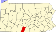 | |
| Townships | ||
| CDP | ||
| Unincorporated communities | ||
| Footnotes | ‡This populated place also has portions in an adjacent county or counties | |
This Fulton County, Pennsylvania state location article is a stub. You can help Wikipedia by expanding it. |