
Dale, Oklahoma
Dale | |
|---|---|
| Motto: "Go Dale" | |
 Dale Location within the state of Oklahoma  Dale Dale (the United States) | |
| Coordinates: 35°23′24″N 97°2′42″W / 35.39000°N 97.04500°W | |
| Country | United States |
| State | Oklahoma |
| County | Pottawatomie |
| Government | |
| Population (2010) | |
| • Total | 181 |
| Time zone | UTC-6 (Central (CST)) |
| • Summer (DST) | UTC-5 (CDT) |
| Area code | (405) |
Dale is a small unincorporated community and census-designated place located on State Highway 270 in Pottawatomie County, Oklahoma. It lies in the North Canadian River bottom, a few miles northwest of Shawnee. The 2010 census recorded a population of 186.[1]
Dale was platted along the Rock Island railroad line before statehood. The Dale Post Office opened October 26, 1893. Initially named King, for John King, an Absentee-Shawnee Indian who owned the allotted land on which the community was founded. The community was renamed in 1895, for Frank Dale, the second Chief Justice of the Territorial Supreme Court (1893-1898).
References
- ^ CensusViewer:Dale, Oklahoma Population. Retrieved August 7, 2013.
Sources
Shirk, George H. Oklahoma Place Names. Norman: University of Oklahoma Press, 1987. ISBN 0-8061-2028-2 .
Municipalities and communities of Pottawatomie County, Oklahoma, United States | ||
|---|---|---|
| Cities | 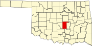 | |
| Towns | ||
| CDP | ||
| Other communities | ||
| Ghost towns | ||
| Footnotes | ‡This populated place also has portions in an adjacent county or counties | |
| International | |
|---|---|
| National | |
This Oklahoma state location article is a stub. You can help Wikipedia by expanding it. |