
Mount Tō
| Mount Tō | |
|---|---|
| 塔ノ岳 | |
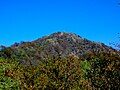
 Mount Tō from Mount Maru | |
| Highest point | |
| Elevation | 1,490.9 m (4,891 ft) |
| Coordinates | 35°27′N 139°9′E / 35.450°N 139.150°E |
| Naming | |
| Language of name | Japanese |
| Pronunciation | [toːnodake] |
| Geography | |
 | |
| Location | On the border of Kiyokawa, Hadano and Yamakita in Kanagawa, Japan |
| Parent range | Tanzawa Mountains |
Mount Tō (塔ノ岳, Tō-no-dake) is a 1,490.9 m (4,891 ft) mountain of Tanzawa Mountains, located on the border of Kiyokawa, Hadano and Yamakita in Kanagawa, Japan.
Outline
Mount Tō is one of the most popular mountains in Tanzawa Mountains. This mountain is a part of Tanzawa-Ōyama Quasi-National Park with other Tanzawa Mountains.
Access
Gallery
-
 Mount Tō from Ōkura-one (10/2008)
 -
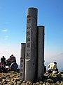 At the top of Mount Tō (10/2008)
 -
 Religious objects at the top of Mount Tō (10/2008)
 -
 Mount Hiru and Mount Fudō from Mount Tō (10/2008)
 -
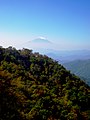 Mount Fuji from Mount Tō (10/2008)
 -
 Mount Ōyama from Mount Tō (10/2008)
 -
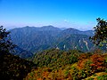 Northwest side view from Mount Tō (10/2008)
 -
 An entrance of Mount Tō (10/2008)


