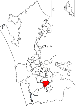
Manurewa Local Board
Manurewa Local Board | |
|---|---|
 | |
| Country | New Zealand |
| Region | Auckland |
| Territorial authority | Auckland |
| Ward | Manurewa-Papakura Ward |
| Legislated | 2010 |
| Government | |
| • Board chair | Joseph Allan |
| Population (June 2023)[1] | |
| • Total | 110,900 |
Local Board Members | |
|---|---|
| Structure | |
Manurewa Action Team | 8 / 8 |
| Elections | |
Last election | 2019 |
Next election | 2022 |
The Manurewa Local Board is one of the 21 local boards of the Auckland Council. It is overseen by the Manurewa-Papakura Ward councillor.[2]
The local board area includes the areas of Wiri, Hillpark, Manurewa East, Homai, Weymouth and Wattle Downs.[2]
2019–2022 term
The current board members, elected at the 2019 local body elections, are:[3]
- Joseph Allan, Manurewa Action Team – (7027 votes)
- Anne Candy, Manurewa Action Team – (6712 votes)
- Rangi Mclean, Manurewa Action Team – (6695 votes)
- Ken Penney, Manurewa Action Team – (6682 votes)
- Glenn Murphy, Manurewa Action Team – (6041 votes)
- Melissa Atama, Manurewa Action Team – (6030 votes)
- David Pizzini, Manurewa Action Team – (5843 votes)
- Tabetha Gorrie, Manurewa Action Team – (4963 votes)
2016–2019 term
The board members who served from the 2016 local body elections to the 2019 elections were:[4]
- Angela Dalton (Chair)
- Stella Cattle (Deputy chair)
- Joseph Allan
- Rangi McLean
- Sarah Colcord
- Angela Cunningham-Marino
- Ken Penney
- Dave Pizzini
References
- ^ "Subnational population estimates (RC, SA2), by age and sex, at 30 June 1996-2023 (2023 boundaries)". Statistics New Zealand. Retrieved 25 October 2023. (regional councils); "Subnational population estimates (TA, SA2), by age and sex, at 30 June 1996-2023 (2023 boundaries)". Statistics New Zealand. Retrieved 25 October 2023. (territorial authorities); "Subnational population estimates (urban rural), by age and sex, at 30 June 1996-2023 (2023 boundaries)". Statistics New Zealand. Retrieved 25 October 2023. (urban areas)
- ^ a b "About Local Board". aucklandcouncil.govt.nz. Auckland Council.
- ^ "Local board members" (PDF). Auckland Council. 18 October 2019. Retrieved 27 October 2019.
- ^ "Contact Local Board". aucklandcouncil.govt.nz. Auckland Council.
