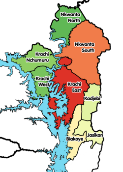
Jasikan District
Appearance
| Jasikan District | ||

| ||
|---|---|---|
| Region | Oti Region | |
| District type | District | |
| District Executive | Hon. Lawrence Kwami Aziale | |
| Capital | Jasikan | |
| Area | 1,355 km² | |
| Population | ||
| ISO 3166 | GH-TV-JA | |
The Jasikan District is one of the nine districts of the Oti Region,[2] and was previously one of the twenty-five (25) districts in the Volta Region.[3] Jasikan district capital and administrative centre is Jasikan.[4]
Boundaries
Jasikan District is bounded by:
- the Lake Volta to the west,
- Kpando Municipal District and Hohoe Municipal District to the south, and
- Krachi East District and Kadjebi District to the north.
Villages
In addition to Jasikan, the capital and administrative centre, Jasikan District contains the following villages:
- Agbesi Madro
- Agomeyor
- Akpafu Todzi
- Akpafu Adorkor
- Akpafu Mempeasem
- Amenyo Yaw
- Akaa
- Akaa Quarters
- Akaa Tank
- Akaa Yaw
- Atakrom
- Atonkor
- Awoma
- Baglo Buem
- Bodada
- Baglo Odumasi
- Dzoku
- Dzolu
- Guama
- Idjeli
- Kayadah
- Kankyi Ekura
- Kudje
- Kute
- Kwanta
- Kwansim
- Lekanti
- New Ayoma
- New Baika
- Nsuta
- Nananko
- Okadjakrom
- Old Baika
- Old Ayoma
- Osei Krom
- Teteman
References and sources
Sources
- ^ "Ghana Statistical Services". statsghana.gov.gh. Retrieved 2020-05-27.
- ^ "One District One Factory (1D1F)". www.1district1factory.gov.gh. Retrieved 2020-05-27.
- ^ Jasikan district
- ^ "One District One Factory (1D1F)". www.1district1factory.gov.gh. Retrieved 2020-05-27.

