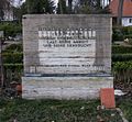
Dahlem Cemetery
Appearance
| Cemetery Dahlem | |
|---|---|
 | |
 | |
| Details | |
| Established | 1908 |
| Location | |
| Country | Germany |
The Cemetery Dahlem (Template:Lang-de, sometimes improperly referred to as Friedhof Dahlem-Dorf) is a cemetery in Berlin-Dahlem. The cemetery was built according to the plans of the architects Friedrich and Wilhelm Hennigs.
Notable burials
- Ernst Otto Beckmann (1853–1923), chemist
- Paul Bildt (1885–1957), film actor
- Emil Bohnke (1888–1928), violist, composer and conductor
- Klaus Croissant (1931–2002), lawyer
- Hermann Diels (1848–1922)
- Heinz Drache (1923–2002)
- Wilhelm Fliess (1858–1928)
- August Gaul (1869–1921)
- Waldemar Grzimek (1918–1984)
- Clemens Hasse (1908–1959)
- Rudolf Havenstein (1857–1923)
- Bernhard Heiliger (1915–1995)
- Fritz Heinemann (1864–1932)
- Werner Hinz (1903–1985)
- Jacobus Henricus van 't Hoff (1852 – 1911), Dutch physical and organic chemist and Nobel laureate
- Lucie Höflich (1883–1956)
- Ludwig Knaus (1829–1910)
- Albert von Le Coq (1860–1930)
- Lilli Lehmann (1848–1929)
- Ernst Lindemann (1894–1941), memorial
- Edgar Speyer (1862–1932), financier and philanthropist
- Otto Heinrich Warburg (1883–1970), physiologist, medical doctor and Nobel laureate
- Rainer Zepperitz (1930–2009)
-
Emil and Lilli Bohnke
-
Siegfried Borris
-
Richard Draemert
-
Family Lindemann
-
Adolf Martens
-
August Gaul
-
Bernhard Heiliger
-
Robert Gragger
-
Waldemar Grzimek
-
Otto Heinrich Warburg
References
- Hans-Jürgen Mende, Debora Paffen: Friedhof Dahlem und St.-Annen-Kirchhof – Ein Friedhofsführer. Christian Simon Verlag Edition Luisenstadt, Berlin 2007, ISBN 978-3-936242-11-9.
External links
Wikimedia Commons has media related to Friedhof Dahlem.
- "Friedhof Dahlem-Dorf - Wissenswertes". Berlin.de (in German). Archived from the original on 2012-07-29. Retrieved 27 March 2012.
52°27′32″N 13°17′10″E / 52.4589125°N 13.28610644°E


