Rundāle Municipality
Rundāle Municipality
Rundāles novads | |
|---|---|
 | |
| Country | |
| Formed | 2009 |
| Centre | Pilsrundāle |
| Government | |
| • Council Chair | Aivars Okmanis (For People and the Land/NA) |
| Area | |
| • Total | 231.1 km2 (89.2 sq mi) |
| Population (2009)[2] | |
| • Total | 4,384 |
| • Density | 19/km2 (49/sq mi) |
| Website | www |
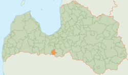
Rundāle Municipality (Latvian: Rundāles novads) is a municipality in Zemgale, Latvia. The municipality was formed in 2009 by merging Rundāle Parish, Svitene Parish and Viesturi Parish, the administrative centre being Pilsrundāle.
It is located in the south-east of Latvia and is only 15 km (9.3 mi) from the town Bauska and 80 km (49.7 mi) from Latvian capital Riga.
The center of the municipality, Pilsrundāle, is the location of the Rundāle Palace, a famous tourist destination and one of the most notable Latvian chateaus.
See also
References
56°25′12″N 24°00′35″E / 56.42000°N 24.00972°E


