Zhenhai Bridge
Zhenhai Bridge | |||||||
|---|---|---|---|---|---|---|---|
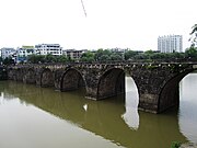
 Zhenhai Bridge in April 2013. | |||||||
| Coordinates | 29°42′39″N 118°17′47″E / 29.710966°N 118.29639°E | ||||||
| Crossed | Heng River | ||||||
| Locale | Tunxi District of Huangshan City, Anhui, China | ||||||
| Characteristics | |||||||
| Design | Arch bridge Stone bridge | ||||||
| Total length | 133 m (436 ft) | ||||||
| Width | 15 m (49 ft) | ||||||
| No. of spans | 7 | ||||||
| History | |||||||
| Construction end | 1699 (reconstruction) | ||||||
| Collapsed | July 7, 2020 | ||||||
| Chinese name | |||||||
| Traditional Chinese | 鎮海橋 | ||||||
| Simplified Chinese | 镇海桥 | ||||||
| |||||||
| Location | |||||||
 | |||||||
Zhenhai Bridge (Chinese: 镇海桥; pinyin: Zhènhǎi Qiáo) was a large stone arch bridge in Tunxi District of Huangshan City, Anhui, China.[1] The bridge went across the Heng River, and had a total history of more than 400 years. The bridge was 133 m (436 ft) long and had 15 m (49 ft) wide.[1]
History
It is said that Zhenhai Bridge was built in the 15th year of Jiajing period (1536) in the Ming dynasty, but according to Xiuning County Annals (休宁县志) and Huizhou Prefecture Chronicles (徽州府志), the bridge was built before 1490.[1] The bridge was rebuilt in 1699, during the Kangxi reign of Qing dynasty.[1]
In October 2019, it was authorized as a "Major Historical and Cultural Site Protected at the National Level in Anhui" by the State Council.[2] On July 7, 2020, Zhenhai Bridge was destroyed in the 2020 China floods.[1]
Gallery
References
- ^ a b c d e Xu Peng (徐鹏); Zhao Jiahui (赵家慧); Liu Jun (刘军) (2020-07-07). 安徽黄山国家级文物保护单位屯溪镇海桥被洪水冲毁. cnr.cn (in Chinese). Retrieved 2020-07-12.
- ^ Zhang Yanling (张燕玲) (2020-07-11). 安徽黄山将打捞被洪水冲垮的古桥原料:尽快原样修复. Chinanews.com (in Chinese). Retrieved 2020-07-12.


