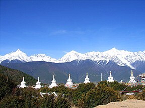
Meili Snow Mountains
| Meili Snow Mountains 梅里雪山 | |
|---|---|
 | |
| Highest point | |
| Peak | Kawagebo |
| Elevation | 6,740 m (22,110 ft) |
| Coordinates | 28°26′14″N 98°41′04″E / 28.43722°N 98.68444°E |
| Dimensions | |
| Length | 200 km (120 mi) North-south |
| Width | 30 km (19 mi) East-west |
| Area | 6,000 km2 (2,300 sq mi) |
| Geography | |
| Country | China |
| State | Yunnan |
| Rivers | Salween and Mekong |
| Settlement | Deqen is the closest settlement of considerable size |
| Parent range | Hengduan Mountain |
Meili Xue Shan (Chinese:梅里雪山, translation: "Mainri snowy range") or Mainri Snow Mountain (Tibetan: སྨན་རི།) is a mountain range in the Chinese province of Yunnan.[1] It lies close to the northwestern boundary of the province and is bounded by the Salween River on the west and the Mekong on the east.[2] The Meili are subrange of the larger Nu Mountains, themselves a constituent range of the Hengduan group.
The crest of the range rises to over 6,000 metres (20,000 ft) above sea level, making for impressive prominence over the river valleys to the east and west, which are between 1,500 metres (4,900 ft) and 1,900 metres (6,200 ft) in elevation. The highest peak is Kawagebo, which rises to 6,740 metres (22,110 ft). Kawagebo is considered sacred for Tibetan Buddhists. Other significant peaks include Mianzimu, Cogar Laka and Jiariren-an. Because of restrictions and dangerous conditions, none of the major peaks in the range have ever been summited.
Expeditions
Meili Xue Shan has received significant attention from climbers due to attempts by Japan and the United States. The first attempt to climb the highest peak, Kawagebo (6740 meters), was the Japan's Joetsu Alpine Club in 1987, followed by the Academic Alpine Club of Kyoto University (AACK). In late 1990, AACK and a joint Chinese expedition attempted the summit from the east side.In January 1991, the climbers were hit by an avalanche during the night. The camp disappeared and all 17 climbers were killed.[3]
From November to December 1996, AACK again challenged the mountain to the summit, but remained unsuccessful. Meanwhile, an American mountaineering team led by Nicholas Clinch summited the mountain four times in 1988, '89, '92 and '93. However, all the peaks, including Mianzimu (6,054m), still remain unclimbed.[3]
Avalanche accident
on January 4, 1991, six Chinese and eleven Japanese mountaineers lost their lives to an avalanche, one of the worst climbing accidents in China.[4] The local people interpreted this accident as a sign of the Warrior God’s anger. Since then, a law has been passed to prevent any further attempts.[5]
References
- ^ "Monkeys and mountains in Yunnan, China". Springer.com. 30 May 2017.
- ^ "Meili Xue Shan". SummitPost. 2004-08-01. Retrieved 2010-03-25.
- ^ a b Tamotsu Nakamura."East of the Himalaya, Part II: Three Rivers Gorges of the Hengduan Mountains". American Alpine Club. 2003-12-20.
- ^ Tetsuro Matsuzawa."Monkeys and mountains in Yunnan, China". Springer.com. 30 May 2017.
- ^ David Abram."Discovering China's 'hidden' Himalaya". Wanderlust. 18 April 2016.

