
Líbeznice
Líbeznice | |
|---|---|
 Mělnická street of Líbeznice | |
 Flag  Coat of arms | |
 Líbeznice Location in the Czech Republic | |
| Coordinates: 50°11′31″N 14°29′37″E / 50.19194°N 14.49361°E | |
| Country | |
| Region | Central Bohemian |
| District | Prague-East |
| First mentioned | 1236 |
| Area | |
| • Total | 4.37 km2 (1.69 sq mi) |
| Elevation | 203 m (666 ft) |
| Population (2020-01-01[1]) | |
| • Total | 2,953 |
| • Density | 680/km2 (1,800/sq mi) |
| Time zone | UTC+1 (CET) |
| • Summer (DST) | UTC+2 (CEST) |
| Postal code | 250 65 |
| Website | www |
Líbeznice is a municipality and village in the Central Bohemian Region of the Czech Republic. It has about 3,000 inhabitants. The municipality is a member of the Povodí Mratínského potoka microregion.
History
The first written record of the village is in a document issued by the Bohemian king Wenceslaus I of Bohemia in 1236.
Gallery
-
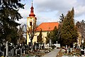 Church in Líbeznice
 -
 Old school house


References
- ^ "Population of Municipalities – 1 January 2020". Czech Statistical Office. 2020-04-30.
External links
- Municipality website (cz)
Wikimedia Commons has media related to Líbeznice.
| Authority control databases: National |
|---|