Myre, Øksnes
Appearance
Myre | |
|---|---|
Village | |
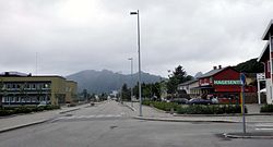
 Myre's main street | |
Location in Nordland | |
| Coordinates: 68°54′50″N 15°04′42″E / 68.9140°N 15.0784°E | |
| Country | Norway |
| Region | Northern Norway |
| County | Nordland |
| District | Vesterålen |
| Municipality | Øksnes |
| Area | |
| • Total | 1.69 km2 (0.65 sq mi) |
| Elevation | 11 m (36 ft) |
| Population (2018)[1] | |
| • Total | 2,086 |
| • Density | 1,234/km2 (3,200/sq mi) |
| Time zone | UTC+01:00 (CET) |
| • Summer (DST) | UTC+02:00 (CEST) |
| Post Code | 8430 Myre |
Myre is the administrative centre of Øksnes Municipality in Nordland county, Norway. It is located on the northwestern part of the island of Langøya in the Vesterålen archipelago. Myre is one of the largest fishing villages in the Vesterålen region. Myre Church is located in this village.
The 1.69-square-kilometre (420-acre) village has a population (2018) of 2,086 which gives the village a population density of 1,234 inhabitants per square kilometre (3,200/sq mi).[1][3]
The newspaper Øksnesavisa is published in Myre.[4]
References
- ^ a b c Statistisk sentralbyrå (1 January 2018). "Urban settlements. Population and area, by municipality".
- ^ "Myre, Øksnes (Nordland)". yr.no. Retrieved 2018-12-30.
- ^ Thorsnæs, Geir, ed. (2009-02-17). "Myre". Store norske leksikon (in Norwegian). Kunnskapsforlaget. Retrieved 2018-12-30.
- ^ Smith-Meyer, Trond; Breivik Pettersen, Øyvind, eds. (2018-02-15). "Øksnesavisa". Store norske leksikon (in Norwegian). Kunnskapsforlaget. Retrieved 2018-12-30.


