
Willacoochee, Georgia
Willacoochee, Georgia | |
|---|---|
 Willacoochee City Hall and Police Department | |
| Motto: Where good people live | |
 Location in Atkinson County and the state of Georgia | |
| Coordinates: 31°20′7″N 83°2′47″W / 31.33528°N 83.04639°W | |
| Country | United States |
| State | Georgia |
| County | Atkinson |
| Incorporated | November 12, 1889 |
| Area | |
| • Total | 3.82 sq mi (9.90 km2) |
| • Land | 3.82 sq mi (9.89 km2) |
| • Water | 0.00 sq mi (0.00 km2) |
| Elevation | 240 ft (73 m) |
| Population (2010) | |
| • Total | 1,391 |
| • Estimate (2019)[2] | 1,354 |
| • Density | 354.45/sq mi (136.85/km2) |
| Time zone | UTC-5 (Eastern (EST)) |
| • Summer (DST) | UTC-4 (EDT) |
| ZIP code | 31650 |
| Area code | 912 |
| FIPS code | 13-82972[3] |
| GNIS feature ID | 0333429[4] |
| Website | www |
Willacoochee is a city in Atkinson County, Georgia, United States, along the Alapaha River. The population was 1,391 at the 2010 census.[5]
History
The Georgia General Assembly incorporated Willacoochee as a town in 1889.[6] Willacoochee is a name derived from the Creek language meaning "home of the wildcats".[7]
Geography
Willacoochee is located at 31°20′7″N 83°2′47″W / 31.33528°N 83.04639°W (31.335175, -83.046381).[8]
According to the U.S. Census Bureau, the city has a total area of 3.8 square miles (9.9 km2), all land.[5]
Demographics
| Census | Pop. | Note | %± |
|---|---|---|---|
| 1890 | 398 | — | |
| 1900 | 471 | 18.3% | |
| 1910 | 960 | 103.8% | |
| 1920 | 1,211 | 26.1% | |
| 1930 | 1,006 | −16.9% | |
| 1940 | 903 | −10.2% | |
| 1950 | 987 | 9.3% | |
| 1960 | 1,061 | 7.5% | |
| 1970 | 1,120 | 5.6% | |
| 1980 | 1,166 | 4.1% | |
| 1990 | 1,205 | 3.3% | |
| 2000 | 1,434 | 19.0% | |
| 2010 | 1,391 | −3.0% | |
| 2019 (est.) | 1,354 | [2] | −2.7% |
| U.S. Decennial Census[9] | |||
As of the census[3] of 2000, there were 1,434 people, 526 households, and 369 families residing in the city. The population density was 378.0 people per square mile (146.1/km2). There were 655 housing units at an average density of 172.7 per square mile (66.7/km2). The racial makeup of the city was 49.79% White, 39.40% African American, 0.49% Asian, 8.65% from other races, and 1.67% from two or more races. Hispanic or Latino of any race were 15.76% of the population.
There were 526 households out of which 35.2% had children under the age of 18 living with them, 46.0% were married couples living together, 18.6% had a female householder with no husband present, and 29.7% were non-families. 26.4% of all households were made up of individuals and 11.6% had someone living alone who was 65 years of age or older. The average household size was 2.68 and the average family size was 3.22.
In the city, the population was spread out with 30.3% under the age of 18, 11.2% from 18 to 24, 27.3% from 25 to 44, 19.7% from 45 to 64, and 11.6% who were 65 years of age or older. The median age was 31 years. For every 100 females, there were 91.5 males. For every 100 females age 18 and over, there were 86.2 males.
The median income for a household in the city was $20,871, and the median income for a family was $25,536. Males had a median income of $21,603 versus $17,115 for females. The per capita income for the city was $9,301. About 23.6% of families and 29.7% of the population were below the poverty line, including 37.6% of those under age 18 and 35.0% of those age 65 or over.
Photos
-
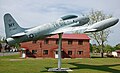 A Lockheed T-33 in Willacoochee. A T-33 crashed here ca. 1960s. Located 31°20'28.7"N 83°02'52.1"W(31.341306,-83.047806)
 -
 McCranie's Turpentine Still, just west of Willacoochee, on the National Register of Historic Places
 -
 Signs indicating drainage divide


References
- ^ "2019 U.S. Gazetteer Files". United States Census Bureau. Retrieved July 9, 2020.
- ^ a b "Population and Housing Unit Estimates". United States Census Bureau. May 24, 2020. Retrieved May 27, 2020.
- ^ a b "U.S. Census website". United States Census Bureau. Retrieved 2008-01-31.
- ^ "US Board on Geographic Names". United States Geological Survey. 2007-10-25. Retrieved 2008-01-31.
- ^ a b "Geographic Identifiers: 2010 Demographic Profile Data (G001): Willacoochee city, Georgia". U.S. Census Bureau, American Factfinder. Archived from the original on February 12, 2020. Retrieved May 6, 2013.
- ^ Acts Passed by the General Assembly of Georgia. J. Johnston. 1889. p. 1006.
- ^ Nestor, Sandy (7 May 2015). Indian Placenames in America. McFarland. p. 50. ISBN 978-0-7864-9339-5.
- ^ "US Gazetteer files: 2010, 2000, and 1990". United States Census Bureau. 2011-02-12. Retrieved 2011-04-23.
- ^ "Census of Population and Housing". Census.gov. Retrieved June 4, 2015.
External links
Municipalities and communities of Atkinson County, Georgia, United States | ||
|---|---|---|
| Cities |  | |
| CDP | ||
| Other unincorporated community | ||