BR-060 (Brazil highway)
Appearance
| BR-060 | |
|---|---|
 | |
 | |
| Location | |
| Country | Brazil |
| Highway system | |
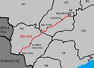
BR-060 is a federal highway of Brazil.[1] The 1459 kilometre road connects Brasilia to Bela Vista, on the Paraguayan border.[2]
It is also designated as part of the Belém-Brasília Highway, in its stretch between Brasília and Anápolis.
Duplication
In the Federal District and in the State of Goiás, the highway has 521 km duplicated, between Brasilia and Jataí. The section between Brasilia and Goiânia fully doubled in 2007. The section between Goiânia and Jataí doubled in 2012.[3][4]
References
- ^ "BR-60". Ministry of Transport. Archived from the original on 22 November 2012. Retrieved 7 June 2011.
- ^ BR 060 map[permanent dead link]
- ^ Trechos duplicados da BR-060/GO serão liberados ao tráfego em março
- ^ BR-060, entre Brasília e Goiânia, é filé mignon de leilão

