Villeret, Belgium
Appearance
Villeret | |
|---|---|
Hamlet | |
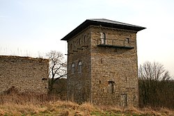
 Le donjon de Villeret (the dungeon of Villeret) | |
| Coordinates: 50°30′25.39″N 4.°39′11.45″E / 50.5070528°N 4.6531806°E | |
| Country | |
| Province | Namur |
| Municipality | Jemeppe-sur-Sambre |
| Elevation | 119 m (390 ft) |
| Time zone | UTC+1 (CET) |
Villeret is a hamlet in the municipality of Jemeppe-sur-Sambre (in the province of Namur), Wallonia Region, Belgium.
Villeret is part of the village of Saint-Martin and is located at the confluence of the east flowing Ligny and another stream flowing down from the north (through Bothey).[1] The Ligny then continues eastwards into the Orneau.
Sights
- Le donjon de Villeret [fr] (the dungeon of Villeret) is an ancient tower fortified in the thirteenth century.[2]
- La ferme de Basse-Villeret (the Lower Villeret Farm) dates from the sixteenth century. The current buildings are nineteenth century.
History
The hamlet of Villeret was on the extreme-left of the Prussian line during the Battle of Ligny on 16 June 1815. It remained in Prussian possession thorough out the battle.[3]
Notes
This article needs additional citations for verification. (October 2016) |
- ^ Siborne 1848, pp. 200–201.
- ^ Donjon de Villeret is located at 50°30′29″N 4°39′03.8″E / 50.50806°N 4.651056°E
- ^ Siborne 1848, pp. 200–201, 210–211.
References
- Siborne, William (1848), The Waterloo Campaign, 1815 (4th ed.), Westminster: A. Constable
External links
- "Villeret Tower", castles.nl, 2016, retrieved 31 October 2016
Wikimedia Commons has media related to Donjon de Villeret.

