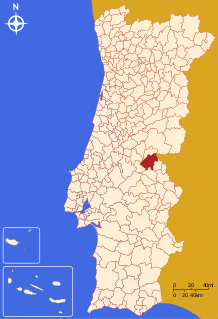
Nisa, Portugal
Nisa | |
|---|---|
 | |
| Coordinates: 39°30′N 7°38′W / 39.500°N 7.633°W | |
| Country | |
| Region | Alentejo |
| Intermunic. comm. | Alto Alentejo |
| District | Portalegre |
| Parishes | 7 |
| Government | |
| • President | Maria Idalina Alves Trindade (PS) |
| Area | |
| • Total | 575.68 km2 (222.27 sq mi) |
| Population (2011) | |
| • Total | 7,450 |
| • Density | 13/km2 (34/sq mi) |
| Time zone | UTC±00:00 (WET) |
| • Summer (DST) | UTC+01:00 (WEST) |
| Local holiday | Easter Monday (date varies) |
| Website | http://www.cm-nisa.pt |
Nisa (Portuguese pronunciation: [ˈnizɐ] ) is a municipality in Portalegre District in Portugal. The population in 2011 was 7,450,[1] in an area of 575.68 km².[2]
The present Mayor is Maria Idalina Alves Trindade (PS - Partido Socialista). The municipal holiday is Easter Monday.
In addition, it lends its name to one of the most famous Portuguese sheep cheeses (Certificate of Protected Origin or D.O.P.).
Parishes
Administratively, the municipality is divided into 7 civil parishes (freguesias):[3]
- Alpalhão
- Arez e Amieira do Tejo
- Espírito Santo, Nossa Senhora da Graça e São Simão
- Montalvão
- Santana
- São Matias
- Tolosa
References
- ^ Instituto Nacional de Estatística
- ^ "Áreas das freguesias, concelhos, distritos e país". Archived from the original on 2018-11-05. Retrieved 2018-11-05.
- ^ Diário da República. "Law nr. 11-A/2013, page 552 81" (pdf) (in Portuguese). Retrieved 29 July 2014.
External links


