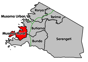
Musoma Rural District
Appearance
Musoma Rural District | |
|---|---|
 | |
| Coordinates: 01°52′S 033°36′E / 1.867°S 33.600°E | |
| Country | Tanzania |
| Region | Mara Region |
| Population (2012) | |
| • Total | 178,356 |
Musoma Rural District is one of the seven districts of Mara Region of Tanzania. Its administrative centre is the town of Musoma. The district is bordered to the east by Butiama District, to the south by Bunda District and to the west and north by Lake Victoria.
According to the 2012 Tanzania National Census, the population of the Musoma Rural District was 178,356.[1]
Transport
There are no paved roads connecting the district. Musoma town can be reached using unpaved regional road R188. Musoma Rural District is connected to Bunda Town by unpaved regional road R187.[2]
Administrative subdivisions
As of 2012, Musoma Rural District was administratively divided into 14 wards.[1]
Wards
Bugoji
Ifulifu
Musanja
- Bugwema
- Bukima
- Bukumi
- Bulinga
- Busambara
- Bwasi
- Kiriba
|
References
- ^ a b "Census 2012". National Bureau of Statistics. Archived from the original on 5 March 2016. Retrieved 9 December 2015.
- ^ "Trunk and Regional Roads in Tanzania". Tanroads. Archived from the original on 8 December 2015. Retrieved 1 December 2015.
