
Carnatic Sultanate
Nawab of the Carnatic Nawab of Arcot | |||||||||
|---|---|---|---|---|---|---|---|---|---|
| 1692–1855 | |||||||||
 Flag | |||||||||
 Nawabate of Arcot marked as "Carnatic" at its height of power. | |||||||||
| Capital | Gingee (1692-1710), Arcot (1710-1768), Chepauk (1768-1855)c | ||||||||
| Common languages | Tamil Urdu | ||||||||
| Religion | Islam | ||||||||
| Government | Nobility | ||||||||
| Nawab | |||||||||
| Historical era | Mughal rule in India Company rule in India | ||||||||
• Progenitor of family appointed governor | 1692 | ||||||||
• Established | 1692 | ||||||||
| 23 September – 14 November 1751 | |||||||||
• Disestablished | 1855 | ||||||||
| |||||||||
| Today part of | |||||||||
The Nawabs of the Carnatic (also referred to as the Nawabs of Arcot) were the nawabs who ruled the Carnatic region of South India between about 1690 and 1801. The Carnatic was a dependency of Hyderabad Deccan, and was under the legal purview of the Nizam of Hyderabad, until their demise.[1][2] They initially had their capital at Arcot in the present-day Indian state of Tamil Nadu. Their rule is an important period in the history of Carnatic and Coromandel regions, in which the Mughal Empire gave way to the rising influence of the Maratha Empire, and later the emergence of the British Raj.
Carnatic
The old province known as the Carnatic, in which Madras (Chennai) was situated, extended from the Krishna river to the Kaveri river, and was bounded on the West by Mysore kingdom and Dindigul, (which formed part of the Sultanate of Mysore). The Northern portion was known as the 'Mughal Carnatic', the Southern the 'Maratha Carnatic' with the Maratha fortresses of Gingee and Ranjana-gad. Carnatic thus was the name commonly given to the region of Southern India that stretches from the East Godavari district of Andhra Pradesh in the North, to the Maratha fort of Ranjana-Gad in the south (including Kaveri delta) and Coromandal Coast in the east to Western Ghats in the west.
History
The Nawabs of the Carnatic trace their origin back to second Caliph Umar ibn al-Khattab.[3] The Nawab of the Carnatic was established by the Mughal Emperor Aurangzeb, who in 1692 appointed Zulfikhar Ali Khan as the first Nawab of the Carnatic, with his seat at Arcot as a reward for his victory over the Marathas led by Rajaram.[4] With the decline of Vijayanagara Empire in 1646, the Hindu viceroys Nayaks, established in Madurai, Tanjore and Kanchi made themselves independent, only in their turn to become tributary to the kings of Golconda and Bijapur, who divided the Carnatic between them. The Nawabdom of the Carnatic controlled a vast territory south of the Krishna river. The Nawab Saadatullah Khan I (1710–1732) moved his court from Gingee to Arcot. His successor Dost Ali (1732–1740) conquered and annexed Madurai in 1736. In 1740, the Maratha forces descended on Arcot. They attacked the Nawab, Dost Ali Khan, in the pass of Damalcherry. In the war that followed, Dost Ali, one of his sons Hasan Ali, and a number of prominent persons lost their lives. This initial success at once enhanced Maratha prestige in the south. From Damalcherry the Marathas proceeded to Arcot, which surrendered to them without much resistance. Chanda Sahib 69 and his son were arrested and sent to Niggpur.
Muhammad Ali Khan Wallajah (1749–1795) became the ruler in 1765.
The growing influences of the English and the French and their colonial wars had a huge impact on the Carnatic. Wallajah supported the English against the French and Hyder Ali, placing him heavily in debt. As a result, he had to surrender much of his territory to the East India Company. Paul Benfield, an English business man, made one of his mayor loans to the Nawab for the purpose of enabling him, who with the aid of the English, had invaded and conquered the Mahratta state of Tanjore.
The thirteenth Nawab, Ghulam Muhammad Ghouse Khan (1825–1855), died without issue, and the British annexed the Carnatic Nawabdom, applying the doctrine of lapse. Ghouse Khan's uncle Azim Jah was created the first Prince of Arcot (Amir-e-Arcot) in 1867 by Queen Victoria, and was given a tax free-pension in perpetuity.
List of rulers
Subedar Nawabs of the Carnatic
| Name | Reign began | Reign ended | |
|---|---|---|---|
| 1 | Zulfiqar Khan Nusrat Jung | 1692 | 1703 |
| 2 | Daud Khan Panni | 1703 | 1710 |
| 3 | Sa'adatullah Khan I | 1710 | 1732 |
| 4 | Dost Ali Khan | 1732 | 1740 |
| 5 | Safdar Ali Khan | 1740 | 1742 |
| 6 | Sa'adatullah Khan II | 1742 | 1744 |
| 7 | Anwaruddin Khan | 1744 | 3 August 1749 |
Semi-independent Nawabs of Carnatic
| Name | Reign began | Reign ended | |
|---|---|---|---|
| 1 | Anwaruddin Khan | 1744 | 3 August 1749 |
Nawabs of Carnatic under European influence
| Names | Reign began | Reign ended | |
|---|---|---|---|
| 1 | Chanda Shahib | 1749 | 1752 |
| 2 | Muhammad Ali Khan Wala-Jah | 3 August 1749 | 16 October 1795 |
| 3 | Umdat ul-Umara | 1795 | 1801 |
| 4 | Azim-ud-Daula* | 1801 | 1819 |
| 5 | Azam Jah | 1819 | 1825 |
| 6 | Ghulam Muhammad Ghouse Khan | 1825 | 1855 |
- Silver shade signifies the French East India Company
- Yellow shade signifies the British East India Company
- * Signed the Carnatic Treaty ceding tax rights
Princes of Arcot
| Lineage | |||||
|---|---|---|---|---|---|
| Amir | Reign | ||||
| Azim Jah | 1867–1874 | ||||
| Sir Zahir-ud-Daula Bahadur | 1874–1879 | ||||
| Intizam-ul-Mulk Muazzal ud-Daula Bahadur | 1879–1889 | ||||
| Sir Muhammad Munawar Khan Bahadur | 1889–1903 | ||||
| Sir Ghulam Muhammad Ali Khan Bahadur | 1903–1952 | ||||
| Ghulam Mohiuddin Khan Bahadur | 1952–1969 | ||||
| Ghulam Mohammed Abdul Khader | 1969–1993 | ||||
| Muhammed Abdul Ali | 1993– | ||||
Gallery
-
![In the year 1702, Nawab Daud Khan, the Mughal Empire's local Subedar of the Carnatic, besieged and blockaded Fort St. George for more than three months,[5] the governor of the fort, Thomas Pitt, was instructed by the British East India Company to vie for peace](//upload.wikimedia.org/wikipedia/commons/thumb/4/4f/Fort_St._George%2C_Chennai.jpg/120px-Fort_St._George%2C_Chennai.jpg) In the year 1702, Nawab Daud Khan, the Mughal Empire's local Subedar of the Carnatic, besieged and blockaded Fort St. George for more than three months,[5] the governor of the fort, Thomas Pitt, was instructed by the British East India Company to vie for peace
In the year 1702, Nawab Daud Khan, the Mughal Empire's local Subedar of the Carnatic, besieged and blockaded Fort St. George for more than three months,[5] the governor of the fort, Thomas Pitt, was instructed by the British East India Company to vie for peace -
 Death of the Nawab Anwaruddin Muhammed Khan in a battle against the French in 1749, by Paul Philipoteaux
 -
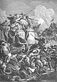
 The Siege of Arcot was a major battle fought between Robert Clive and the combined forces of the Mughal Empire's Nawab of the Carnatic, Chanda Sahib, assisted by a small number of troops from the French East India Company
 -
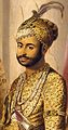
 Muhammad Ali Khan Wallajah, (1717–1795)
 -
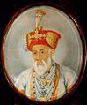
 Umdat ul-Umara the Nawab of the Carnatic was a covert ally of Tipu Sultan
 -
 Azim Jah, eleventh and penultimate Nawab of the Carnatic, 1867 to 1874.
 -
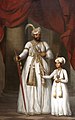 Azim-ud-Daula, Nawab of the Carnatic and his son Azam Jah.
![In the year 1702, Nawab Daud Khan, the Mughal Empire's local Subedar of the Carnatic, besieged and blockaded Fort St. George for more than three months,[5] the governor of the fort, Thomas Pitt, was instructed by the British East India Company to vie for peace](/wiki/File:Fort_St._George,_Chennai.jpg)


See also
- Carnatic Wars
- Amir Mahal
- Nawab of Masulipatam
- Nawab of Banganapalle
- Nawab of Savanur
- History of Tamil Nadu
References
- ^ Publishing, Britannica Educational (1 April 2010). The History of India. Britannica Educational Publishing. p. 219. ISBN 9781615302017.
- ^ Ramaswami, N. S. (1 January 1984). Political History of Carnatic Under the Nawabs. Abhinav Publications. p. 104. ISBN 9780836412628.
- ^ "The Hindu : Tamil Nadu / Chennai News : Web site on Nawabs of the Carnatic". www.hindu.com. Retrieved 18 March 2018.
- ^ "Mughal Empire 1526-1707 by Sanderson Beck". San.beck.org. Retrieved 4 March 2012.
- ^ Terence R. Blackburn. A miscellany of mutinies and massacres in India.