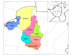
Chegutu District
Chegutu District | |
|---|---|
 Chegutu District (light pink) in Mashonaland West Province | |
| Coordinates: 18°00′S 30°00′E / 18.000°S 30.000°E | |
| Country | Zimbabwe |
| Province | Mashonaland West |
Chegutu District is a district of Mashonaland West Province, Zimbabwe.
Location
The district is located in Mashonaland West Province, in central northern Zimbabwe. Chegutu District is bordered by Kadoma District to the south and west, Zvimba District to the north and to the east, lies Mazoe District in Mashonaland Central Province. Its main town, Chegutu, is located about 120 kilometres (75 mi), by road, southwest of Harare, the capital of Zimbabwe and the largest city in that country.[1]
Overview
Chegutu District is primarily a mining district. Large gold deposits are found in the district and two large gold mines are located there, namely the Butterfly Mine and the Giant Mine. The district headquarters is located in Chegutu, a city which lies of the Harare-Bulawayo Road, (Highway A-5), with an estimated population of 47,294 as of 2004.[2]
Population
The current population of Chegutu District is not publicly known. In 1992, the national census put the district population at 191,909 people. By 2002's national census, that population count had increased to 224,589.[3] The next national population census in Zimbabwe is scheduled from 18 August 2012 through 28 August 2012.[4]
