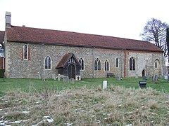
Great Bricett
Appearance
| Great Bricett | |
|---|---|
 Church of St Mary & St Laurence | |
Location within Suffolk | |
| Area | 3.77 km2 (1.46 sq mi) |
| Population | 1,530 (2011)[1] |
| • Density | 406/km2 (1,050/sq mi) |
| OS grid reference | TM040508 |
| District | |
| Shire county | |
| Region | |
| Country | England |
| Sovereign state | United Kingdom |
| Post town | Ipswich |
| Postcode district | IP7 |
| Police | Suffolk |
| Fire | Suffolk |
| Ambulance | East of England |
| UK Parliament | |
Great Bricett is a village and civil parish in the county of Suffolk, England. At the 2011 census the population was recorded as 1,530.[2] It has strong links with the neighbouring RAF Wattisham which partly falls within the parish boundary.
Notable residents
- Sean Hedges-Quinn (1968- ), sculptor, animator, and film model and prop-maker.
See also
Wikimedia Commons has media related to Great Bricett.
References
- ^ "Civil Parish population 2011". Neighbourhood Statistics. Office for National Statistics. Retrieved 21 August 2016.
- ^ "Custom report - Nomis - Official Labour Market Statistics". www.nomisweb.co.uk. Retrieved 12 August 2020.
External links

