
Barima-Waini
Barima-Waini
Region 1 | |
|---|---|
Administrative Region | |
 | |
 Map of Guyana showing Barima-Waini region | |
| Country | Claimed by |
| Regional Capital | Mabaruma |
| Area | |
| • Total | 20,399 km2 (7,876 sq mi) |
| Population (2012 census) | |
| • Total | 26,941 |
| • Density | 1.3/km2 (3.4/sq mi) |
| [2] | |
Barima-Waini (Region 1) is a region of Esequiban Guyana, a territory in dispute by Guyana and Venezuela. Venezuela claims the territory as part of Delta Amacuro state.
The region is located in the northwest of the country. It covers an area of 20,339 km². It borders the Atlantic Ocean to the north, the region of Pomeroon-Supenaam to the east, the region of Cuyuni-Mazaruni to the south and Venezuela to the west.[2]
History
Prior to the 1980 administrative reform in Guyana, the Barima-Waini Region was known as the 'North West district'.[3]
Mabaruma became the administrative centre when it was decided that the former centre, Morawhanna, was too susceptible to flooding. During the late 1960s and early 1970s, serious consideration was once given to moving the capital of Guyana to this area.[citation needed]
Etymology
The region is named after two rivers that flow through the region; the Barima River and the Waini River.
Geography
Barima-Waini is a heavily forested region. The Atlantic coastal strip of Region One features a number of beaches, including, from west to east, Almond Beach, Luri Beach, Shell Beach, Turtle Beach, Foxes Beach, Iron-punt Beach, Pawpaw Beach and Father's Beach. Marine turtles nest on some of these beaches. There are also a number of Amerindian communities in this area, including Santa Rosa Mission.
Economy
The main economic activities in the Barima-Waini region are forestry and gold mining.[2] The northern and northeastern sections include thousands of acres of rich alluvial soil, of which its main crops include coffee, ground provisions (such as cassava, eddoes and yams), cabbage, beans, corn, peanuts, and citrus fruits. (This is the area which supplies the famous Pomeroon casareep).
The Matthews Ridge-Port Kaituma manganese industry was discontinued when falling world prices made it uneconomical to continue.
Major Settlements, Services and Facilities
Major settlements include Mabaruma (the regional capital), Port Kaituma, Matthew's Ridge, Morawhanna, Towakaima, Koriabo, Hosororo, Arakaka and Moruca.
The region has two secondary schools, North West Secondary School in Mabaruma, established in 1965, and Santa Rosa Secondary School, established in 1992.
Population
The Government of Guyana has administered three official censuses since the 1980 administrative reforms, in 1980, 1991 and 2002.[4] In 2002, the population of Barima-Waini was recorded at 24,275 people.[5] Official census records for the population of Barima-Waini are as follows:
- 2012 : 26,941
- 2002 : 24,275
- 1991 : 18,428
- 1980 : 18,329
Communities
(including name variants):
- Acquero (Akwero, Aqueero)
- Arakaka
- Barabina Hill
- Baramani (Baramanna, Baramanni, Barimanni)
- Baramita
- Chinese Landing
- Cummingsburg
- Five Star (Five Star Landing, Five Stars)
- Hobediah
- Hosororo (Hossororo)
- Hotakwai
- Iguapa (Igupa Village)
- Ipotaikuru
- Issororo
- Kaituma
- Kamwatta Hill
- Kariakau (Kariaku)
- Kokerit (Kokerit Landing, Kokerite)
- Konora Village (Konoro Village)
- Koriabo
- Kumaka
- Kwebanna (Kwabanna)
- La Juanita (Juanita)
- Mabaruma (administrative centre)
- Manari (Manari Village)
- Manawarin
- Matthew's Ridge
- Mission Landing
- Morawhanna
- Moruca
- Mount Everard
- Mubohina
- Pakera
- Parapimai
- Port Kaituma
- Red Hill Settlement
- Saint Bede's Mission (Saint Bedes)
- Saint Benedict Mission
- Santa Cruz
- Santa Rosa (Santa Rosa Mission)
- Sinclair Landing
- Surprise Hill
- Towakaima (Towakaima Landing, Towokaima Falls)
- Waikerebi Mission
- Waramuri (Waramuri Mission)
- Waropoko Mission
- Wauna-Yarakita (Wauna-Yarikita)
Gallery
-
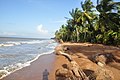 Shell Beach
 -
 Mabaruma
 -
 Santa Rosa School
 -
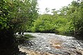 Baramani River
 -
 Kumaka District Hospital


See also
References
- ^ "Official Announcements". Archived from the original on 8 September 2016. Retrieved 28 July 2016.
- ^ a b c Macmillan Publishers (2009). "Administrative Regions - 1 and 7". Macmillan Junior Atlas: Guyana. Oxford: Macmillan Caribbean. p. 36. ISBN 9780333934173.
- ^ UK Directorate of Overseas Surveys 1:500,000 map of Guyana NW sheet, 1966.
- ^ Beaie, Sonkarley Tiatun (19 September 2007). "Chapter 3: National Redistribution and Internal Migration" (PDF). 2002 Population and Housing Census - Guyana National Report. Bureau of Statistics. p. 51. Archived from the original (PDF) on 17 February 2012. Retrieved 29 August 2012.
- ^ Beaie, Sonkarley Tiatun (19 September 2007). "National Population Trends: Size, Growth and Distribution" (PDF Download). 2002 Population and Housing Census - Guyana National Report. Bureau of Statistics. p. 25. Retrieved 29 August 2012.
7°40′01″N 59°45′00″W / 7.667°N 59.750°W
This article about a location in Venezuela is a stub. You can help Wikipedia by expanding it. |