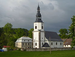
Bílý Kostel nad Nisou
Appearance
Bílý Kostel nad Nisou | |
|---|---|
 Church of Saint Nicholas | |
| Coordinates: 50°49′24″N 14°55′28″E / 50.82333°N 14.92444°E | |
| Country | |
| Region | Liberec |
| District | Liberec |
| Founded | 13th century |
| Area | |
• Total | 25.73 km2 (9.93 sq mi) |
| Elevation | 275 m (902 ft) |
| Population (2020-01-01[1]) | |
• Total | 1,043 |
| • Density | 41/km2 (100/sq mi) |
| Time zone | UTC+1 (CET) |
| • Summer (DST) | UTC+2 (CEST) |
| Postal code | 463 31 |
| Website | www |
Bílý Kostel nad Nisou (Template:Lang-de) is a municipality and village in Liberec District in the Liberec Region of the Czech Republic. It has a population of about 1,000. Bílý Kostel nad Nisou lies approximately 11 kilometres (7 mi) west of Liberec and 90 km (56 mi) north of Prague.
Gallery
-
Municipal office
-
Floods in 2010
-
Local part Pekařka
-
Local part Panenská Hůrka
References
- ^ "Population of Municipalities – 1 January 2020". Czech Statistical Office. 2020-04-30.
External links
- Official website (in Czech)
- UIR.cz Územně identifikační registr ČR (in Czech)
Wikimedia Commons has media related to Bílý Kostel nad Nisou.


