Beaune-la-Rolande
Appearance
You can help expand this article with text translated from the corresponding article in French. (August 2012) Click [show] for important translation instructions.
|
Beaune-la-Rolande | |
|---|---|
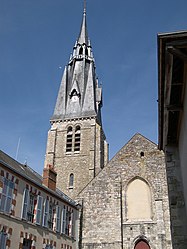
 Church of Saint Martin | |
| Coordinates: 48°04′14″N 2°25′48″E / 48.0706°N 2.43°E | |
| Country | France |
| Region | Centre-Val de Loire |
| Department | Loiret |
| Arrondissement | Pithiviers |
| Canton | Malesherbes |
| Intercommunality | Beaunois |
| Government | |
| • Mayor (2008–2014) | Claude Renucci |
| Area 1 | 20.55 km2 (7.93 sq mi) |
| Population (2021)[1] | 1,998 |
| • Density | 97/km2 (250/sq mi) |
| Time zone | UTC+01:00 (CET) |
| • Summer (DST) | UTC+02:00 (CEST) |
| INSEE/Postal code | 45030 /45340 |
| Elevation | 91–119 m (299–390 ft) |
| 1 French Land Register data, which excludes lakes, ponds, glaciers > 1 km2 (0.386 sq mi or 247 acres) and river estuaries. | |
Beaune-la-Rolande is a commune in the Loiret department in north-central France.
History
On 28 November 1870 it was the site of a battle during the Franco-Prussian War, in which French impressionist painter Frédéric Bazille was killed.
During World War II, it was the site of the Nazi Beaune-la-Rolande internment camp for Jews. Polish artist Zber was imprisoned there from 1941 to 1942.[2]

Population
| Year | Pop. | ±% |
|---|---|---|
| 1793 | 2,028 | — |
| 1800 | 2,057 | +1.4% |
| 1806 | 2,062 | +0.2% |
| 1821 | 2,169 | +5.2% |
| 1831 | 2,119 | −2.3% |
| 1836 | 2,128 | +0.4% |
| 1841 | 2,122 | −0.3% |
| 1846 | 2,174 | +2.5% |
| 1851 | 2,131 | −2.0% |
| 1856 | 2,055 | −3.6% |
| 1861 | 1,987 | −3.3% |
| 1866 | 1,962 | −1.3% |
| 1872 | 1,818 | −7.3% |
| 1876 | 1,967 | +8.2% |
| 1881 | 1,874 | −4.7% |
| 1886 | 1,845 | −1.5% |
| 1891 | 1,792 | −2.9% |
| 1896 | 1,753 | −2.2% |
| 1901 | 1,860 | +6.1% |
| 1906 | 1,776 | −4.5% |
| 1911 | 1,762 | −0.8% |
| 1921 | 1,620 | −8.1% |
| 1926 | 1,695 | +4.6% |
| 1931 | 1,703 | +0.5% |
| 1936 | 1,746 | +2.5% |
| 1946 | 1,765 | +1.1% |
| 1954 | 1,721 | −2.5% |
| 1962 | 1,758 | +2.1% |
| 1968 | 1,792 | +1.9% |
| 1975 | 1,929 | +7.6% |
| 1982 | 1,928 | −0.1% |
| 1990 | 1,877 | −2.6% |
| 1999 | 2,097 | +11.7% |
| 2006 | 2,073 | −1.1% |
| 2009 | 2,039 | −1.6% |
See also
References
- ^ "Populations légales 2021" (in French). The National Institute of Statistics and Economic Studies. 28 December 2023.
- ^ Paris for Dummies. Wiley Publishing, Inc. 2007. pp. 220. ISBN 978-0-470-08584-4.
Wikimedia Commons has media related to Beaune-la-Rolande.


