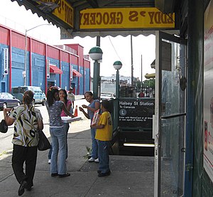
Halsey Street station (BMT Canarsie Line)
Halsey Street | |||||||
|---|---|---|---|---|---|---|---|
 Eastbound street stair | |||||||
| Station statistics | |||||||
| Address | Halsey Street & Wyckoff Avenue Queens, NY 11385 Brooklyn, NY 11237 | ||||||
| Borough | On the border of Queens and Brooklyn (mostly in Queens) | ||||||
| Locale | Ridgewood, Queens and Bushwick, Brooklyn | ||||||
| Coordinates | 40°41′46″N 73°54′18″W / 40.696095°N 73.905029°W | ||||||
| Division | B (BMT)[1] | ||||||
| Line | BMT Canarsie Line | ||||||
| Services | L | ||||||
| Transit | |||||||
| Structure | Underground | ||||||
| Platforms | 2 side platforms | ||||||
| Tracks | 2 | ||||||
| Other information | |||||||
| Opened | July 14, 1928 | ||||||
| Opposite- direction transfer | No | ||||||
| Traffic | |||||||
| 2023 | 1,713,746[2] | ||||||
| Rank | 185 out of 423[2] | ||||||
| Station succession | |||||||
| Next north | Template:NYCS next | ||||||
| Next south | Template:NYCS next | ||||||
| |||||||
| |||||||
| |||||||
Halsey Street is a station on the BMT Canarsie Line of the New York City Subway. Located on the border of Ridgewood, Queens, and Bushwick, Brooklyn, at the intersection of Halsey Street and Wyckoff Avenue, it is served by the L train at all times.
History
Track layout | ||||||||||||||||||||||||||||||||||||||||||||||||||||||||
|---|---|---|---|---|---|---|---|---|---|---|---|---|---|---|---|---|---|---|---|---|---|---|---|---|---|---|---|---|---|---|---|---|---|---|---|---|---|---|---|---|---|---|---|---|---|---|---|---|---|---|---|---|---|---|---|---|
| ||||||||||||||||||||||||||||||||||||||||||||||||||||||||
Halsey Street opened on July 14, 1928,[4] as part of an extension of the Canarsie Line. This extension connected Montrose Avenue, which had opened four years earlier, to Broadway Junction, which was the western end of the already-operating elevated line to Canarsie.
Station layout
| Ground | Street level | Exit/entrance |
| Platform level | Side platform | |
| Westbound | ← | |
| Eastbound | | |
| Side platform | ||

This station has two tracks and two side platforms. Since all intersections on this section of Wyckoff Avenue are T intersections, the platforms are offset, with the Manhattan-bound platform built about 60 feet (18 m) further to the east than the Canarsie-bound one.[5] Also, since the Brooklyn-Queens border travels on Wyckoff Avenue for part of the length of this station before turning south, the entire Manhattan-bound platform, as well as the eastern half of the Canarsie-bound platform, is located in Queens.
Both platforms have their original mosaic tile band that is colored blue and green with yellowish accents.[5] "H" tablets on blue background run along the tile bands at regular intervals.[5] The name tablets read "HALSEY ST." in gold serif font on a blue background and a green, yellow, and blue border.[5] There are also directional signs in gold serif font and outline on a blue background.[5] One of the platforms formerly had two bathrooms. Yellow i-beam columns run along both platforms at regular intervals with alternating ones having the standard black station name plate in white lettering.[5]
Exits
All fare control areas at this station are platform level and there are no crossovers or crossunders. The full-time side is at the west (railroad north) end of the platforms. On the Manhattan-bound side, a turnstile bank leads to the full-time token booth and one staircase going up to the northwest corner of Wyckoff Avenue and George Street. On the Canarsie-bound side, a turnstile bank leads to a part-time customer assistance booth and one staircase going up to the southwest corner of Halsey Street and Wyckoff Avenue.[6]
Both platforms have an unstaffed fare control area at their east (railroad south) end. A set of full height turnstiles leads to a single street stair. The Manhattan-bound staircase goes up to the northeast corner of Norman Street and Wyckoff Avenue while the Canarsie-bound staircase goes up to the southwest corner of Covert Street and Wyckoff Avenue.[6]
References
- ^ "Glossary". Second Avenue Subway Supplemental Draft Environmental Impact Statement (SDEIS) (PDF). Vol. 1. Metropolitan Transportation Authority. March 4, 2003. pp. 1–2. Archived from the original (PDF) on February 26, 2021. Retrieved January 1, 2021.
- ^ a b "Annual Subway Ridership (2018–2023)". Metropolitan Transportation Authority. 2023. Retrieved April 20, 2024.
- ^ "Annual Subway Ridership (2018–2023)". Metropolitan Transportation Authority. 2023. Retrieved April 20, 2024.
- ^ "Last Link of New 14th St-E.D. Subway To Be Opened Today: First Train This Afternoon Will Carry Officials – Citizens to Celebrate". Brooklyn Daily Eagle. July 14, 1928. Retrieved August 25, 2015.
- ^ a b c d e f "www.nycsubway.org". www.nycsubway.org.
- ^ a b "MTA Neighborhood Maps: Ocean Hill" (PDF). mta.info. Metropolitan Transportation Authority. 2015. Retrieved July 20, 2016.
External links
- nycsubway.org – BMT Canarsie: Halsey Street
- Station Reporter — "L Train". stationreporter.net. Archived from the original on June 30, 2013.
- The Subway Nut — Halsey Street Pictures.
- Halsey Street entrance from Google Maps Street View
- George Street entrance from Google Maps Street View
- Covert Street entrance from Google Maps Street View
- Norman Street entrance from Google Maps Street View
- Platforms from Google Maps Street View


