Marracuene
Appearance
Marracuene | |
|---|---|
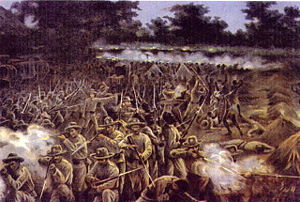
 Marracuene at war. 1899. | |
| Coordinates: 25°44′S 32°41′E / 25.733°S 32.683°E | |
| Country | |
| Provinces | Maputo Province |
| District | Marracuene District |
Marracuene, earlier known as Vila Luísa is a town in Mozambique's Maputo Province in Marracuene District, located 30 km north of Maputo on the Incomati River. The Parque de Campismo de Marracuene, a popular camping destination, is located nearby.
History
On February 2, 1895, Marracuene was the site of a decisive battle between Portuguese commander António José Enes and Gaza emperor Gungunyane; the Portuguese defeated the larger Gaza forces by means of repeating rifles and a machine gun.
Tourism
Marracuene served as a popular tourist destination in Mozambique's colonial era thanks to a 21-mile beach on the Indian Ocean; the town also served as a key link in the Lourenço Marques Railway System.
References
- Hance, William A. and Irene S. Van Dongen. "Lourenço Marques in Delagoa Bay." Economic Geography 33.3 (1957): 238–256.
- Wheeler, Douglas L. "Gungunyane the Negotiator: A Study in African Diplomacy." The Journal of African History 9.4 (1968): 585–602.
External links
25°44′S 32°41′E / 25.733°S 32.683°E

