Svatobořice-Mistřín
Appearance
Svatobořice-Mistřín | |
|---|---|
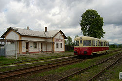
 Disused train station in Svatobořice | |
| Coordinates: 48°58′39″N 17°5′20″E / 48.97750°N 17.08889°E | |
| Country | |
| Region | South Moravian |
| District | Hodonín |
| Established | 1964 |
| Government | |
| • Mayor | František Měchura |
| Area | |
| • Total | 23.11 km2 (8.92 sq mi) |
| Elevation | 193 m (633 ft) |
| Population (2020-01-01[1]) | |
| • Total | 3,530 |
| • Density | 150/km2 (400/sq mi) |
| Time zone | UTC+1 (CET) |
| • Summer (DST) | UTC+2 (CEST) |
| Postal code | 696 04 |
| Website | www |
Svatobořice-Mistřín is a municipality in the South Moravian Region of the Czech Republic. It has around 3,500 inhabitants.
Administrative parts
The municipality is made up of villages of Svatobořice and Mistřín.
History
Mistřín was first mentioned in the 13th century, Svatobořice was first mentioned in 1349. The two formerly separate municipalities merged in 1964.[2]
References
- ^ "Population of Municipalities – 1 January 2020". Czech Statistical Office. 2020-04-30.
- ^ "Historie" (in Czech). Obec Svatobořice-Mistřín. Retrieved 2020-09-15.
External links
Wikimedia Commons has media related to Svatobořice-Mistřín.
- Official website (cz)


