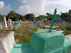
Loché, Yucatán
Appearance
Loché | |
|---|---|
Town | |
 Cemetery | |
| Coordinates: 21°39′18″N 88°16′14″W / 21.65500°N 88.27056°W | |
| Country | |
| State | |
| Elevation | 7 m (23 ft) |
| Population | 1,306 |
| Time zone | UTC-5 (Southeast (US Eastern)) |
| Postal Code | 97610 |
| Area code | 986 |
Loché is a community in the Panabá Municipality, Yucatan, Mexico. The name Loché is of Mayan origin.[1] The town of Cenote mentioned in early Spanish records is sometimes identified with it.[2]
References
- ^ "Loché - Yucatán". en.nuestro-mexico.com. Retrieved 6 October 2017.
- ^ Cook, Sherburne Friend; Borah, Woodrow Wilson (1971). Essays in Population History: Mexico and the Caribbean, Volume 2. Berkeley: University of California Press. p. 35. ISBN 9780520022720.

