
Sathenahalli
13°03′26″N 76°20′21″E / 13.057344°N 76.339075°E Sathenahalli is a small village in Hassan district of India.
Sathenahally | |
|---|---|
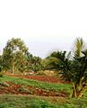
.jpg) Sathenahalli village |
Location
Sathenahalli lies on the Mysore - Arsikere highway. It comes under Channarayapatna taluk of Hassan district in Karnataka state, India.
Economy
The village is completely agrarian in nature. In 2015, the village recorded the highest rainfall in the region.[1]
Postal code
There is a post office in the village and the PIN code is 573212.
Image gallery
-
 Sathenahalli
 -
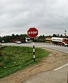 Highway Junction
.jpg)

See also
References
- ^ "Sathenahalli in Hassan records highest rainfall of 71mm". The Times of India. Retrieved 16 February 2019.
This article related to a location in Hassan district, Karnataka, India is a stub. You can help Wikipedia by expanding it. |