
St. Amant, Louisiana
This article needs additional citations for verification. (January 2009) |
St. Amant | |
|---|---|
 St. Amant Location of St. Amant in Louisiana | |
| Coordinates: 30°13′29″N 90°52′08″W / 30.22472°N 90.86889°W | |
| Country | United States |
| State | Louisiana |
| Parish | Ascension |
| Elevation | 7 ft (2 m) |
| Time zone | UTC-6 (CST) |
| • Summer (DST) | UTC-5 (CDT) |
| Area code | 225 |
St. Amant (or Saint Amant) is an unincorporated community located in Ascension Parish, in the U.S. state of Louisiana. This community has not been incorporated into a city or town. It is situated about 25 miles south-east of Baton Rouge. and 50 miles north west of New Orleans. It is named after the St. Amant family, some of the early settlers in the region. The Saint Amant post office has the ZIP code of 70774.[1]
Geography
St. Amant is located near the largest city in Ascension Parish, Gonzales, which is three miles to the north-west.
Education
The following schools are located within the community:
- St. Amant High School [2]
- St. Amant Middle School[3]
- St. Amant Primary School[4]
- Lake Elementary School[5]
The high school is located on Highway 431.[6] St. Amant middle school, primary school and the post office are located on Highway 429.[7][8] Lake Elementary School is located on Highway 431.[9]
Notable people
- Reid Brignac, baseball shortstop
- John "Hot Rod" Williams, NBA basketball player.
Notable events
St. Amant became the subject of national headlines after the 2016 Louisiana Floods, due to the devastation in the area. The area was visited by then-presidential candidate, Donald J. Trump.[10]
Municipalities and communities of Ascension Parish, Louisiana, United States | ||
|---|---|---|
| Cities | 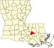 | |
| Town | ||
| CDPs | ||
| Other unincorporated communities | ||
| Footnotes | ‡This populated place also has portions in an adjacent parish or parishes | |
References
- ^ https://tools.usps.com/go/POLocatorDetailsAction!input.action?&radius=20&locationType=po&locationID=1380263
- ^ http://apsb.org/subhome/StAmantHigh
- ^ http://apsb.org/subhome/StAmantMiddle
- ^ https://www.apsb.org/subhome/StAmantPrimary
- ^ https://www.apsb.org/index.cfm?md=pagebuilder&tmp=home&alias=leswelcome
- ^ http://apsb.org/subhome/StAmantHigh
- ^ http://apsb.org/subhome/StAmantMiddle
- ^ https://tools.usps.com/go/POLocatorDetailsAction!input.action?&radius=20&locationType=po&locationID=1380263
- ^ https://www.apsb.org/index.cfm?md=pagebuilder&tmp=home&alias=leswelcome
- ^ https://www.theadvocate.com/louisiana_flood_2016/article_c30c8178-661a-11e6-81c9-3f4b02af0c03.html
| Authority control databases: Geographic |
|---|
This Louisiana state location article is a stub. You can help Wikipedia by expanding it. |