Woryny
Woryny | |
|---|---|
Village | |
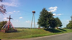
 Wood storks nest in Woryny | |
 | |
| Country | |
| Voivodeship | Warmian-Masurian |
| County | Bartoszyce |
| Gmina | Gmina Górowo Iławeckie |
Woryny [vɔˈrɨnɨ] (German: Worienen) is a village in the administrative district of Gmina Górowo Iławeckie, within Bartoszyce County, Warmian-Masurian Voivodeship, in northern Poland, close to the border with the Kaliningrad Oblast of Russia.[1]
History
Throughout the Napoleonic Battle of Eylau in February 1807 the French generals Nicolas Dahlmann (General Colonel, Commandant des chasseur à cheval de la Garde Impériale francaise) and Jean-Joseph Ange d'Hautpoul were buried at the manor house of Worienen but later exhumed and transferred to France[2]
Until 1945 the area was part of the German Province of East Prussia, Worienen was occupied by the Soviet Red Army in February 1945 throughout the East Prussian Offensive. After World War II the area was placed under Polish administration according to the post-war Potsdam Agreement. Germans fled or were expelled and replaced with Poles, many of them expelled from the Polish areas annexed by the Soviet Union or forced to settle in the area throughout the Operation Vistula in 1947.
References
54°18′31″N 20°34′12″E / 54.30861°N 20.57000°E
