Jump to content

An Hảo

Coordinates: 10°28′15″N 105°02′40″E / 10.47083°N 105.04444°E / 10.47083; 105.04444
From Wikipedia, the free encyclopedia

This is an old revision of this page, as edited by TerraCyprus (talk | contribs) at 00:57, 28 October 2020 (→‎top: clean up, pushpin_map, coordinates, timezone, replaced: |timezone = → |timezone_link = Time in Vietnam |timezone =, removed: <!--See the Table at Infobox Settlement for all fields and descriptions of u). The present address (URL) is a permanent link to this revision, which may differ significantly from the current revision.

An Hảo
Rural commune and village
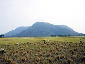
View of Núi Cấm
View of Núi Cấm
Country Vietnam
ProvinceAn Giang
DistrictTịnh Biên
Time zoneUTC+07:00 (Indochina Time)

An Hảo is a rural commune () and village of the Tịnh Biên District of An Giang Province, Vietnam. Núi Cấm (the forbidden mountain), also known as Thiên Cấm Sơn is a famous mountain in An Hảo commune.[1]

References

10°28′15″N 105°02′40″E / 10.47083°N 105.04444°E / 10.47083; 105.04444