
Éternité Bay
| Éternité Bay | |
|---|---|
| Baie Éternité Error {{native name checker}}: parameter value is malformed (help) | |
 | |
 Éternité Bay | |
 | |
| Location | Rivière-Éternité, Quebec, Canada |
| Coordinates | 48°18′23″N 70°19′13″W / 48.30639°N 70.32028°W |
| Part of | Saguenay River |
| Primary inflows | Éternité River |
| Managing agency | Sépaq |
| Max. length | 1 km (0.62 mi) |
| Max. width | 2.5 km (1.6 mi) |
Éternité Bay (French: Baie Éternité, meaning Eternity Bay) is a bay located south of the Saguenay Fjord at Rivière-Éternité, Quebec, Canada.[1][2] It is part of Saguenay Fjord National Park.
Geography
Perpendicular to Saguenay River, it is 1.0 km (0.62 mi) wide by 2.5 km (1.6 mi) long. The Éternité River drains into it at the head of the bay.[3]
In front of Éternité Bay, the Saguenay fjord reaches its maximum depth there of 472 m (1,549 ft).[4]
Two capes are at the mouth of the bay along the Saguenay: Cap Trinité (411 m (1,348 ft)) to the northwest, Cap Éternité (454 m (1,490 ft)) at the South-East.
History
On Cap Trinité is the statue of Notre-Dame-du-Saguenay.
-
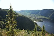 Baie Éternité seen from Cap Éternité
 -
 Mouth of the Éternité River


References
External links
![]() Media related to Éternité Bay at Wikimedia Commons
Media related to Éternité Bay at Wikimedia Commons