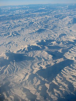
Central Makran Range
Appearance


The Central Makran Range is a mountain range in the Makran region, in southwestern section of Balochistan Province, in southwestern Pakistan.
Geography
It is one of three ranges in the mountain ranges system. The range's peaks are 2,000–3,000 metres (6,600–9,800 ft) in elevation.
Mirani Dam across the Dasht River forms a reservoir in the range, to provide irrigation water in the region and drinking water for the city of Gwadar.
Geology
The Central Makran Range is primarily made up of limestone and sandstone. It was formed when the northwestern Indian Plate collided with the Asian Plate.
Adjacent ranges
There are three main ranges in Balochistan:
- the Makran Coastal Range (up to about 1,500 metres (4,900 ft));
- the Central Makran Range (2,000–3,000 metres (6,600–9,800 ft));
- the Siahan Range (1,000–2,000 metres (3,300–6,600 ft)).
See also
References
External links
Wikimedia Commons has media related to Central Makran Range, Pakistan.
26°40′N 64°30′E / 26.667°N 64.500°E
