Apple River (Wisconsin)
| Apple River | |
|---|---|
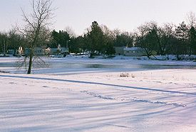
 Apple River in Amery, Wisconsin | |
 | |
| Location | |
| Country | United States |
| Physical characteristics | |
| Source | |
| • location | Wisconsin |
| Length | 77.5 miles (124.7 km) |
| Basin size | St. Croix-Mississippi |
- For the tributary of the Mississippi River in southwestern Wisconsin and northwestern Illinois, see Apple River (Illinois). For the town in northwestern Wisconsin, see Apple River, Wisconsin.
The Apple River is a 77.5-mile-long (124.7 km)[1] tributary of the St. Croix River in northwestern Wisconsin in the United States. Via the St. Croix, it is part of the watershed of the Mississippi River.
It issues from Staples Lake in Barron County and flows generally southwestwardly through Polk and St. Croix counties. In northern Polk County, it gathers the Fox Creek near White Ash Lake and traverses several lakes throughout its course. The river flows through the city of Amery and the villages of Star Prairie and Somerset. It joins the St. Croix River 7 miles (11 km) northeast of Stillwater, Minnesota.
In the Ojibwe language, the Apple River is called Waabiziipinikaan-ziibi, meaning "River Abundant with Swan Potatoes". This name was translated into French, but only pomme (apple) of the French word for "potato" (pomme de terre - apple from the earth) was translated into English.
The Apple River was once an important route of trade for the logging industry; timber was floated downstream from logging camps in the north to a sawmill in Amery, Wisconsin where it was cut, loaded onto trains and transported throughout the region. Today, the river generates tourism revenue through recreation and resorts. Its relatively gentle rapids make it very popular for canoeing, tubing, camping, concerts, and is a popular fishing spot through all seasons. Tubing involves floating on a river on top of an inner tube.
See also
The Apple river is visited annually by as many as 500,000 visitors.
References
- ^ U.S. Geological Survey. National Hydrography Dataset high-resolution flowline data. The National Map Archived 2012-04-05 at WebCite, accessed October 5, 2012
- WI DNR 24K Hydrography
- Columbia Gazetteer of North America entry
- DeLorme (1992). Wisconsin Atlas & Gazetteer. Freeport, Maine: DeLorme. ISBN 0-89933-247-1.
- U.S. Geological Survey Geographic Names Information System: Apple River
