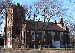
Nysted, Nebraska
Nysted, Nebraska | |
|---|---|
 | |
| Coordinates: 41°06′N 98°36′W / 41.1°N 98.6°W | |
| Country | |
| State | |
| County | Howard |
Nysted is an unincorporated community in Howard County, Nebraska, United States.[1]
History
Nysted was founded in 1883.[2] A majority of the early settlers being natives of Denmark caused the name Nysted to be selected.[3][4]
A post office was established at Nysted in 1883, and remained in operation until it was discontinued in 1918.[5]
References
- ^ U.S. Geological Survey Geographic Names Information System: Nysted, Nebraska
- ^ Federal Writers' Project (1939). Nebraska: A Guide to the Cornhusker State. WPA. p. 293. ISBN 0-8032-6918-8.
- ^ Hickey, Donald R.; Wunder, Susan A.; Wunder, John R. (2007). Nebraska Moments. U of Nebraska Press. p. 118. ISBN 978-0-8032-1572-6.
- ^ Fitzpatrick, Lillian L. (1960). Nebraska Place-Names. University of Nebraska Press. p. 81. ISBN 0-8032-5060-6. A 1925 edition is available for download at University of Nebraska—Lincoln Digital Commons.
- ^ "Howard County". Jim Forte Postal History. Retrieved 13 August 2014.
41°08′04″N 98°36′52″W / 41.13444°N 98.61444°W


