
Chilocco, Oklahoma
Chilocco, Oklahoma | |
|---|---|
 Chilocco  Chilocco | |
| Coordinates: 36°59′20″N 97°04′11″W / 36.98889°N 97.06972°W | |
| Country | United States |
| State | Oklahoma |
| County | Kay |
| Elevation | 1,152 ft (351 m) |
| Time zone | UTC-6 (Central (CST)) |
| • Summer (DST) | UTC-5 (CDT) |
| Area code | 580 |
| GNIS feature ID | 1091297[1] |
Chilocco is an unincorporated community in Kay County, Oklahoma, United States.[1] The community is located in northern Kay County, 5.4 miles (8.7 km) south-southwest of Arkansas City, Kansas.[2]
Its name was derived from that of the Chilocco Indian School, which in turn most likely took its name from the Creek tci lako, which literally meant "big deer" but typically referred to a horse. A post office opened in Chilocco on March 27, 1883.[3]
References
- ^ a b c "Chilocco". Geographic Names Information System. United States Geological Survey, United States Department of the Interior.
- ^ ""Oklahoma Atlas & Gazetteer, DeLorme, 1st ed., 1998, p. 23 ISBN 0899332838
- ^ Shirk, George H. (1974). Oklahoma Place Names (2 ed.). Norman, Oklahoma: University of Oklahoma Press. p. 50. ISBN 0806111402.
Municipalities and communities of Kay County, Oklahoma, United States | ||
|---|---|---|
| Cities | 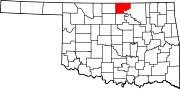 | |
| Towns | ||
| CDPs | ||
| Other communities | ||
| Ghost towns | ||
This Oklahoma state location article is a stub. You can help Wikipedia by expanding it. |