Hospital Rock Tunnels
Appearance
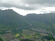
 Hospital Rock Tunnels in the foreground, to the left. The larger Tetsuo Harano Tunnels are seen entering the range in the background. | |
| Overview | |
|---|---|
| Official name | memorial rock |
| Location | near Kaneohe, Hawaii |
| Coordinates | 21°24′07″N 157°48′54″W / 21.401816°N 157.81505°W |
| Route | |
| Technical | |
| Length | 354 feet (108 m) Kaneohe bound 353 feet (108 m) Halawa bound |
| No. of lanes | 4 |
The Hospital Rock Tunnels are a small pair of highway tunnels passing through a ridge on the edge of the Ko‘olau Range on the island of O‘ahu, Hawaiʻi, USA. The tunnels are located on Interstate H-3, which connects Kaneohe with Interstate H-1 at Hālawa near Pearl Harbor, and are 354 feet (108 m) long Kaneohe bound and 353 feet (108 m) long Halawa bound. The tunnels are "cut and cover" tunnels.[1]
Also nearby are the larger Tetsuo Harano Tunnels.
References
- ^ Sanders, Craig. "H3: The Island Interstate". Federal Highway Administration. Retrieved 14 September 2020.
