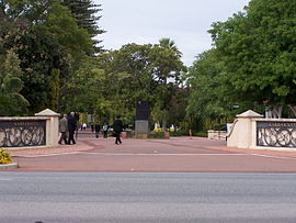
Karrakatta, Western Australia
Appearance
| Karrakatta Perth, Western Australia | |||||||||||||||
|---|---|---|---|---|---|---|---|---|---|---|---|---|---|---|---|
 Main entrance to Karrakatta Cemetery | |||||||||||||||
| Coordinates | 31°58′05″S 115°48′04″E / 31.968°S 115.801°E | ||||||||||||||
| Population | 22 (SAL 2021)[1] | ||||||||||||||
| Postcode(s) | 6010 | ||||||||||||||
| Location | 8 km (5 mi) WSW of Perth CBD | ||||||||||||||
| LGA(s) | City of Nedlands | ||||||||||||||
| State electorate(s) | Nedlands | ||||||||||||||
| Federal division(s) | Curtin | ||||||||||||||
| |||||||||||||||
Karrakatta is a suburb of Perth, Western Australia, located within the City of Nedlands and 7 km west of the central business district. Its postcode is 6010.
Karrakatta is composed of two distinct areas, due to the Fremantle railway line passing through the suburb. On the south side is Karrakatta Cemetery,[2][3] which began service in 1899,[4] with a small industrial area occupied by monument builders, associated companies and the depot for City of Nedlands.
The other area north of the railway line and Karrakatta railway station is occupied by the Australian Defence Force's Irwin Army Barracks.
See also
Notes
- ^ Australian Bureau of Statistics (28 June 2022). "Karrakatta (suburb and locality)". Australian Census 2021 QuickStats. Retrieved 28 June 2022.
- ^ Coleman, Shalom; Western Australia. Karrakatta Cemetery Board (1979), A short history of the Karrakatta cemetery (PBK ed.), Karrakatta Cemetery Board of Trustees, ISBN 978-0-9595203-0-9
- ^ Western Australia. Metropolitan Cemeteries Board (1998), Karrakatta Cemetery : historical walk trail, Metropolitan Cemeteries Board, retrieved 13 March 2013
- ^ Liveris, Leonie B. (Leonie Beth); Western Australia. Metropolitan Cemeteries Board (1999), Memories eternal : the first 100 years of Karrakatta, Metropolitan Cemeteries Board, ISBN 978-0-646-37207-5

