Achthoven, Montfoort
Appearance
Achthoven | |
|---|---|
Hamlet | |
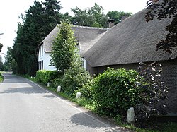
 House De Witte Swaen in Achthoven | |
 | |
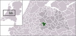
 Achthoven in the municipality of Montfoort. | |
| Coordinates: 52°3′33″N 4°59′39″E / 52.05917°N 4.99417°E | |
| Country | Netherlands |
| Province | Utrecht (province) |
| Municipality | Montfoort |
| Population | |
| • Total | 170 |
| Time zone | UTC+1 (CET) |
| • Summer (DST) | UTC+2 (CEST) |
Achthoven is a hamlet in the Dutch province of Utrecht. It is a part of the municipality of Montfoort, and lies about 6 km northwest of IJsselstein.[1] Between 1818 and 1857, Achthoven was a separate municipality; it merged with Linschoten in 1857.[2]
Achthoven is sometimes divided into two hamlets: Achthoven-West and Achthoven-Oost.[1]
The hamlet has about 170 inhabitants.[3]
References
- ^ a b ANWB Topografische Atlas Nederland, Topografische Dienst and ANWB, 2005.
- ^ Ad van der Meer and Onno Boonstra, Repertorium van Nederlandse gemeenten, KNAW, 2011.
- ^ Statistics Netherlands (CBS), Kerncijfers postcodegebieden 2004 "Archived copy". Archived from the original on 2006-08-27. Retrieved 2006-03-07.
{{cite web}}: CS1 maint: archived copy as title (link): postcode 3417BW, 3417PC, 3417PD, 3417PE.

