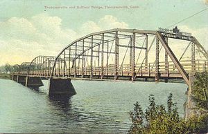
Suffield and Thompsonville Bridge
Suffield and Thompsonville Bridge | |
|---|---|
 | |
| Coordinates | 41°59′57″N 72°36′25.56″W / 41.99917°N 72.6071000°W |
| Carries | vehicular and pedestrian traffic |
| Crosses | Connecticut River |
| Locale | Suffield, Connecticut to Thompsonville, Connecticut |
| Characteristics | |
| Design | 5-span iron through truss bridge |
| Total length | 1,060 feet (323 m) |
| History | |
| Construction start | August 15, 1892 |
| Construction end | January 14, 1893 |
| Opened | February 20, 1893 |
| Closed | 1971 |
| Statistics | |
| Toll | 3¢ for pedestrians 12¢ for single teams 15¢ for double teams |
| Location | |
 | |
The Suffield and Thompsonville Bridge was a 5-span iron through truss bridge over the Connecticut River located between present day Suffield, Connecticut and Thompsonville, Connecticut (Enfield). It connected Burbank Avenue in Suffield with Main Street in Thompsonville. Its four stone piers still stand today.
History

In 1889 the Suffield and Thompsonville Bridge Company was granted a charter to construct an iron bridge across the Connecticut River between Thompsonville and Suffield. The Berlin Iron Bridge Company of Berlin, Connecticut was the contractor for the ironwork, and O.W. Weand of Reading, Pennsylvania was the contractor for the stonework. The first toll-taker was Nathan Hemenway. Tolls were initially three cents for pedestrians, twelve cents for single teams and fifteen cents for double teams.
The Enfield–Suffield Veterans Bridge opened downstream in 1966, and the Suffield and Thompsonville Bridge closed shortly thereafter. The ironwork was removed, but the four piers remain in the river.[1]
See also
References
- ^ Oglesby, Scott. "Connecticut Route 190". www.kurumi.com. Retrieved 2016-09-28.
External links
 Media related to Suffield and Thompsonville Bridge at Wikimedia Commons
- Enfield Historical Society
- Suffield, Connecticut
- Enfield, Connecticut
- Truss bridges in the United States
- Demolished bridges in the United States
- Bridges over the Connecticut River
- Bridges completed in 1808
- Bridges completed in 1893
- Bridges in Hartford County, Connecticut
- Road bridges in Connecticut
- Former toll bridges in Connecticut
- Northeastern United States bridge (structure) stubs
- Connecticut building and structure stubs
- Connecticut transportation stubs
