
La Chapelle-Chaussée
La Chapelle-Chaussée
Chapel-ar-Galc'hed | |
|---|---|
 Chateau | |
Location of La Chapelle-Chaussée  | |
 La Chapelle-Chaussée  La Chapelle-Chaussée | |
| Coordinates: 48°16′21″N 1°51′12″W / 48.2725°N 1.8533°W | |
| Country | France |
| Region | Brittany |
| Department | Ille-et-Vilaine |
| Arrondissement | Rennes |
| Canton | Montauban-de-Bretagne |
| Intercommunality | Rennes Métropole |
| Government | |
| • Mayor (2014–2020) | Pascal Pinault |
| Area 1 | 14.76 km2 (5.70 sq mi) |
| Population (2021)[1] | 1,300 |
| • Density | 88/km2 (230/sq mi) |
| Time zone | UTC+01:00 (CET) |
| • Summer (DST) | UTC+02:00 (CEST) |
| INSEE/Postal code | 35058 /35630 |
| Elevation | 84–148 m (276–486 ft) |
| 1 French Land Register data, which excludes lakes, ponds, glaciers > 1 km2 (0.386 sq mi or 247 acres) and river estuaries. | |
La Chapelle-Chaussée (Breton: Chapel-ar-Galc'hed) is a commune in the Ille-et-Vilaine department of Brittany in north-western France.
Population
Inhabitants of La Chapelle-Chaussée are called Chapellois in French.
| Year | Pop. | ±% |
|---|---|---|
| 1962 | 692 | — |
| 1968 | 591 | −14.6% |
| 1975 | 546 | −7.6% |
| 1982 | 597 | +9.3% |
| 1990 | 624 | +4.5% |
| 1999 | 763 | +22.3% |
| 2008 | 1,111 | +45.6% |
Gallery
-
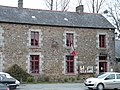 Town hall
 -
 Saint-Pierre church


See also
References
- ^ "Populations légales 2021". The National Institute of Statistics and Economic Studies. 28 December 2023.
External links
Wikimedia Commons has media related to La Chapelle-Chaussée.
- Official website (in French)
- Base Mérimée: Search for heritage in the commune, Ministère français de la Culture. (in French)
- Mayors of Ille-et-Vilaine Association (in French)
| Authority control databases: National |
|---|
This Ille-et-Vilaine geographical article is a stub. You can help Wikipedia by expanding it. |