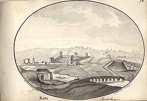
Kells Castle
Móta Cheanannais | |||||||||
 Panorama of Kells in 1794. Motte is visible to the right. | |||||||||
| Alternative name | Kells Motte | ||||||||
|---|---|---|---|---|---|---|---|---|---|
| Location | Kells Road, Kells, County Kilkenny, Ireland | ||||||||
| Region | Kings River Valley | ||||||||
| Coordinates | 52°32′30″N 7°16′23″W / 52.541647°N 7.272985°W | ||||||||
| Type | motte | ||||||||
| Diameter | 12 m (39 ft) | ||||||||
| History | |||||||||
| Builder | Geoffrey FitzRobert | ||||||||
| Material | earth | ||||||||
| Founded | late 12th century | ||||||||
| Periods | Norman Ireland | ||||||||
| Cultures | Cambro-Norman | ||||||||
| Associated with | Normans | ||||||||
| Site notes | |||||||||
| Public access | yes | ||||||||
| Designation |
| ||||||||
Kells Castle or Kells Motte is a motte-and-bailey and National Monument in Kells, County Kilkenny, Ireland.[1][2]
Location
Kells Castle is located just south of the Kells Bridge which crosses the Kings River, immediately behind Delaney's Bar.[3][4]
History and archaeology
Motte-and-bailey castles were a primitive type of castle built after the Norman invasion, a mound of earth topped by a wooden palisade and tower.[5] Kells motte was built on a gravel platform (possibly originally an island in the Kings River) by Geoffrey FitzRobert in the late 12th century. It was an important site for extending Norman colonisation and economic exploitation in the region, which was formerly the Gaelic Irish Kingdom of Osraige.[6] It was abandoned by the following century when the focus of the town shifted to the bailey, and later to Kells Priory.[7][8]
References
- ^ Garry (9 September 2010). "Kells Castles Kilkenny". Retrieved 12 October 2020 – via Flickr.
- ^ "Historic Castles of County Kilkenny Ireland".
- ^ "The mystery of the eyes in Kells Co Kilkenny".
- ^ "Kells Augustinian Priory - Monastic Ireland".
- ^ "Geograph:: Callan Motte (C) dougf". Retrieved 5 September 2016.
- ^ Davies, R. R. (29 June 1990). "Domination and Conquest: The Experience of Ireland, Scotland and Wales, 1100-1300". Cambridge University Press – via Google Books.
- ^ Barry, T. B.; Culleton, E.; Empey, C. A. (1 January 1984). "Kells Motte, County Kilkenny". Proceedings of the Royal Irish Academy, Section C. 84C: 157–170. JSTOR 25506115.
- ^ "10046 « Excavations".

