Podkamennaya Tunguska
| Podkamennaya Tunguska | |
|---|---|
 | |
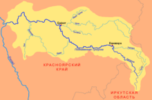
 Map of the Podkamennaya Tunguska basin | |
| Location | |
| Country | Russia |
| Physical characteristics | |
| Mouth | Yenisey |
• coordinates | 61°35′40″N 90°08′00″E / 61.5944°N 90.1333°E |
| Length | 1,865 km (1,159 mi) |
| Basin size | 240,000 km2 (93,000 sq mi) |
| Discharge | |
| • average | 1,750 m3/s (62,000 cu ft/s) |
| Basin features | |
| Progression | Yenisey→ Kara Sea |
The Podkamennaya Tunguska (Template:Lang-ru, literally Tunguska under the stones; Template:Lang-evn[citation needed]) also known as Middle Tunguska or Stony Tunguska, is a river in Krasnoyarsk Krai, Russia.
Course
The Podkamennaya Tunguska is an eastern, right tributary of the Yenisey. It is 1,865 kilometres (1,159 mi) long, and has a drainage basin of 240,000 square kilometres (93,000 sq mi).[1] The name of the river comes from the fact that it flows under pebble fields without open water.[clarification needed] As early as 1610 Russians from Mangazeya had passed the Podkamennaya Tunguska's confluence with the Yenisey; by the 1620s Mangazeya Cossacks and trappers had ascended it seeking fur-tribute from the local Tungus clans.[2][3] The Tunguska event in June 1908 occurred near this river, some 8 km (5.0 mi) SSE of Lake Cheko.
In its upper reaches the river is known as Katanga.[4] Its valley forms the northern boundary of the Yenisey Range, north of which rises the Tunguska Plateau.[5][6] The main tributaries of the Podkamennaya Tunguska are the Tetere and Chunya from the right, and Kamo and Velmo from the left.[4]
See also
References
- ^ "Река ПОДКАМЕН.ТУНГУСКА in the State Water Register of Russia". textual.ru (in Russian).
- ^ Fisher, Raymond Henry (1943). The Russian Fur Trade, 1550–1700. University of California Press.
- ^ Forsyth, James (1992). A History of the Peoples of Siberia: Russia's North Asian colony 1581–1990. Cambridge: Cambridge University Press.
- ^ a b Подкаменная Тунгуска, Great Soviet Encyclopedia
- ^ Енисейский кряж, Great Soviet Encyclopedia
- ^ Geographic Encyclopedia - Tunguska Plateau (in Russian)
