Baldy Mountain (Manitoba)
Appearance
| Baldy Mountain | |
|---|---|
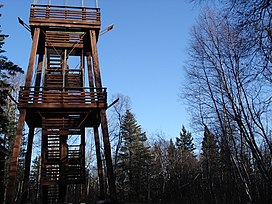
 Observation tower on Baldy Mountain | |
| Highest point | |
| Elevation | 832 m (2,730 ft) |
| Coordinates | 51°28′07″N 100°43′42″W / 51.46861°N 100.72833°W |
| Geography | |
| Parent range | Manitoba Escarpment |
| Topo map | Baldy Mountain 62 N/7 1:50,000 |
Baldy Mountain is the highest peak in Manitoba, Canada.[1] It is located in the Duck Mountain Provincial Park, North of Grand View. It is 832 m (2,730 ft) tall,[2] making it the highest mountain in the 563 km (350 mi) long Manitoba Escarpment.
References
- ^ "Baldy Mountain, Manitoba". Peakbagger.com. 2004. Retrieved 18 December 2020.
- ^ "Dauphin Lake Integrated Watershed Management Plan" (PDF). Government of Manitoba. 2015. Retrieved 18 December 2020.

