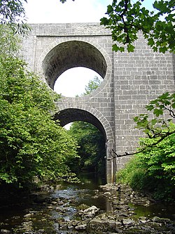
Spectacle Bridge
Appearance
Spectacle Bridge | |
|---|---|
 | |
| Coordinates | 53°01′30″N 9°18′25″W / 53.025°N 9.30706°W |
| Carries | N67 |
| Crosses | Aille River |
| Locale | County Clare |
| Characteristics | |
| Design | Arch bridge |
| Material | Stone |
| No. of spans | One |
| History | |
| Designer | John Hill |
| Opened | May 1816 |
| Location | |
 | |
The Spectacle Bridge is a bridge built in May 1816 over the Aille River in County Clare, Ireland.
History
The Spectacle Bridge was designed by County Clare's county engineer, John Hill. It spans the Aille River gorge on the road between Lisdoonvarna and Ennistymon on the N67. The gorge is up to 25 metres deep at points, and a solid bridge would have been too heavy. Hill then designed a tunnel running through the centre to make the structure lighter. This design resulted in the name, the Spectacle Bridge.[1][2][3][4] It is a single arch with cut-stone coping and voussoirs, and splayed piers.[5]
The bridge was renovated in 2001.[4]
References
- ^ Mulvihill, Mary (2 August 2008). "A spectacle". The Irish Times. Retrieved 21 December 2020.
- ^ "1850 – Spectacle Bridge, Lisdoonvarna, Co. Clare". Archiseek - Irish Architecture. 23 March 2014. Retrieved 21 December 2020.
- ^ "Holiday Haunts on the West Coast of Clare Ireland - Cliffs of Moher, Lisdoonvarna, Doolin". www.clarelibrary.ie. Retrieved 21 December 2020.
- ^ a b Mulvihill, Mary (2019). Ingenious Ireland (2nd ed.). Four Courts Press. pp. 333–334. ISBN 9781846828225.
- ^ "Spectacle Bridge, AUGHISKA BEG, Lisdoonvarna, County Clare". Buildings of Ireland. Retrieved 21 December 2020.
