
Ramer, Alabama
Ramer, Alabama | |
|---|---|
 Ramer, Alabama  Ramer, Alabama | |
| Coordinates: 32°03′02″N 86°13′17″W / 32.05056°N 86.22139°W | |
| Country | United States |
| State | Alabama |
| County | Montgomery |
| Elevation | 469 ft (143 m) |
| Time zone | UTC-6 (Central (CST)) |
| • Summer (DST) | UTC-5 (CDT) |
| ZIP code | 36069 |
| Area code | 334 |
| GNIS feature ID | 153107[1] |
Ramer, also known as Athens, is an unincorporated community located in Montgomery County, Alabama, United States. The elevation is 469 feet (143 m). The community is located 23.9 miles (38.5 km) from the city of Montgomery.
History
Ramer was originally known as Athens. When the town applied for a post office, Athens was already in use by a city in Alabama. Instead, the community became known as Ramer, which is the name of a nearby creek.[2] A post office opened under the name Ramer in 1851.[3]
Notable people
- Joe Caffie, former outfielder for the Cleveland Indians
- Oscar Gamble, former Major League Baseball outfielder and designated hitter
References
- ^ "Ramer". Geographic Names Information System. United States Geological Survey, United States Department of the Interior.
- ^ Foscue, Virginia (1989). Place Names in Alabama. Tuscaloosa: The University of Alabama Press. p. 116. ISBN 0-8173-0410-X.
- ^ "Montgomery County". Jim Forte Postal History. Retrieved January 18, 2015.
Municipalities and communities of Montgomery County, Alabama, United States | ||
|---|---|---|
| Cities | 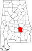 | |
| Towns | ||
| Unincorporated communities | ||
| Indian reservation | ||
| Footnotes | ‡This populated place also has portions in an adjacent county or counties | |
This Montgomery County, Alabama state location article is a stub. You can help Wikipedia by expanding it. |